**Bring your RV/Camper! 10 Acre Getaway Lot Bordering Public Land!**

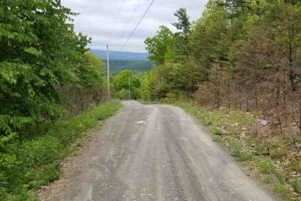
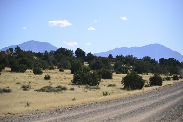
Get ready for your ultimate getaway or second home property! What could be better than a 10 acre lot that borders state land, is accessible by dirt road, but with proximity to historic Route 66 with rolling hills and trees? As you can see from the photos, you can definitely get a camper up here!

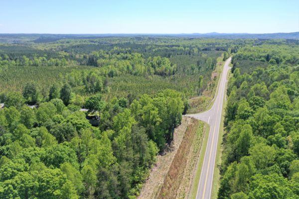
This property is just south of route 19 that runs from Kingman to Flagstaff. It is off the beaten path, but still accessible. State land shares a border with this parcel to the west.

These photos and video were taken May 28, 2020.

  • Prop ID: 301-30-052C
  • Size: 10 Acres
  • Address: Near Peach Springs, AZ 86434
  • Annual Taxes: $140.18 (Current)
  • Mobile Homes: Allowed, with primary residence established, for travel trailer.
  • RV: You can camp on the property 10 days at a time, one month between camping trips, three times a year. Can apply for temporary dwelling permit to live in RV while SFR is being built.
  • Septic: Would need to be installed
  • Water: Would need to be hauled or well drilled.
  • Electricity Off grid. No power lines nearby.
    Terrain Property is rolling.
    Road Access
    Nearest access to the property would be by an unnamed dirt road on the South. Lots borders a state owned land on the North and Western portion.
    Flood Zone The parcel are located in FEMA Zone D, which means that the area has not been study for flood hazards.
    HOA None
    Abbreviated Legal Description
    A rectangular portion being the SW4NW4NW4 of said section AKA SW4 of Parcel 645 Green View Ranches Contains 10.00 acres.
    Complete Legal Desc: The Southwest Quarter of the Northwest Quarter of the Northwest Quarter of Sec 11 T24N R10W of the Gila and Salt River Base and Meridian, Yavapai County Arizona aka Southwest Quarter of Parcel 645 Green View Ranches.
    GPS Coordinates:
    Center: 35.484931, -113.309785
    NW: 35.485882, -113.310916
    NE: 35.485875, -113.308645
    SW: 35.484068, -113.310909
    SE: 35.484062, -113.308671

Continue reading

A Beautiful 1.901 Acre Lot with Approved Perc Test 5 Minutes from I-99

Beat the Heat of Summer! 1.901 Acre Lot in the Mountains of Bedford PA

Are you looking for the perfect spot to build? We have got the property for you! Conveniently located on Black Bear Lane less than 5 minutes from I-99 outside of St. Clairsville Township, this lot has access to several towns and communities in Pennsylvania. It has an approved perc test and power nearby! Scroll all the way down for property details

Picture yourself enjoying a breath of fresh air in the morning and enjoying the views from your deck! 

This 1.901 acre treed lot is the best location for those who are looking for a retreat house, a second cabin that is close to nature, but also has proximity to the conveniences of everyday life!

There is so much to do in the area: Hiking, Biking, Hunting, Canoeing, Kayaking, Golfing – you name it! You can even ATV and snowmobile in nearby State Parks! A full description of available activities is below.

This property has great proximity to Bedford, PA. Here, you will find all of your shopping and grocery needs, as there are lots of stores, banks and restaurants that you can visit. Bedford is also home to the beautiful Omni Bedford Springs Resort.

Fisher’s Country Store – 5.8 miles

Rose Family Farm – 6.4 miles

McDonalds – 7.6 miles

Shell Gas Station – 7.9 miles

First National Bank – 9.9 miles

Burger King – 14.9 miles

Weis Markets (grocery store) – 16.2 miles

Dragon Chinese Restaurant – 17.2 miles

Walmart – 17.4 miles

Lakes, a river, parks and State Game Lands are just a few miles away from the property. Between these, you have access to biking, hiking, golfing, canoeing and Kayaking, ATV’ing, snowmobiling, hunting, fishing, bird watching, and other activities for all visitors. 

Biking Bedford County offers a variety of on and off-road biking experiences. For the on-road cyclists, the County has several bike loops with varying degrees of difficulty.

Hiking There are many excellent hiking trails to explore in Bedford County. You can also hike or walk along the first stage of the Bedford Heritage Trail, as well as the Pike to Bike and H&BT Rail Trail.

You can also head to Shawnee State Park where you will find 15 miles of hiking trails ranging from easy to moderately difficult. We recommend the popular Lake Shore Trail for a simple 3.4 mile loop around the lake.

For mountain hiking, Blue Knob State Park is your spot. This state park has 17 miles of moderate to difficult trails through changing timber types and crossing streams. 

For long hikes, the Mid State Trail, part of the Great Eastern Trail, is Pennsylvania’s longest footpath trail. It stretches over 260 miles from Maryland to New York State passing directly through the center of Everett, PA. Tenley Park in Everett offers camping by permit for trail hikers. 

Golfing: There are three 18-hole and one 9-hole golf courses to choose from! 

Canoe & Kayak: With several creeks, a river and a few lakes, kayaking is a great way to explore some of the waterways in Bedford County. The Raystown Branch of the Juniata River is a gentle river that can provide a very pleasant day of paddling or fishing. 

Canoing and Kayaking can also be done at Shawnee State Park, near Schellsburg, Koon Lake and Lake Gordon in Southern Bedford County, and Raystown Lake, which is fed by the Raystown Branch.

ATV and Snowmobiling: You can bring your ATV or snowmobile to Bedford County and explore several miles of trails. Both James Buchanan and Gallitzin State Forests, which serve as home to many different kinds of ATV and snowmobile trails, including the 17 mile summer Martin Hill ATV Trail System, the Babcock Snowmobile Trail and several other trails in the State Park system.

Hunting and Fishing: Home to 8 Game Lands, Bedford County will give you plenty of opportunities to hunt and fish to your heart’s content!

State Parks in Bedford County

Blue Knob State Park: This is our “Big Mountain” park. This year-round wilderness adventure consists of over 5,600 acres of woodland. An extensive hiking trail system offers 17 miles of trails through changing timber types, across cool streams and occasionally passing by pioneer homesteads that are slowly yielding to the forces of nature. 

Shawnee State Park: Shawnee is known as “Lake Park,” which consists of 3,983 acres with a 451 acre lake. Picnic tables and fire rings are available. Non-powered and electric boats are permitted and rentals are available. A 12 mile hiking / biking system is also suitable for cross country skiing.

Warriors Path State Park: This small park (334 acres) is bounded on 3 sides by the Raystown Branch of the Juniata River. This is a good area for canoeing / kayaking or picnics.

Property Details

Center:

40.140493, -78.497507

NW:

40.140856, -78.498167

NE:

40.141047, -78.497157

SW:

40.140433, -78.498168

SE:

40.139900, -78.496951

Yearly Taxes $254.00
Tax Status Current
Assessed Value $20,100.00
Zone Type No Zoning. The only place in Bedford County that has zoning is Bedford Borough.
Mobile Homes Placement of mobile homes in the subdivision is prohibited.
RV
Campers or RV may be parked on a lot for a period of not more than two continuous weeks. It shall not be used as a long term residence on any lot without the approval of the ACC/POA, and then, only under special circumstances such as, a required residence during construction of the main residence, or other compelling reasons, as approved by the ACC/POA.
Sewer Septic is needed – have passed perc test.
Water Well can be installed.
Electricity
There are power lines in the area. Nearest post is about 800′ away in most recent satelitte image
Terrain Property is sloped.
Road Access Property can be accessed via a gravel road easement access.
Flood Zone Not in a floodzone area.
HOA: $75/year for road maintenance
Abbreviated Legal Description SPLIT FROM E6-66
Complete Legal Desc: ALL that certain parcel of land situate in East St. Clair Township, Bedford County, Commonwealth of Pennsylvania, bounded and described as follows to wit:

BEGINNING at a point or iron pin on the centerline of a private roadway known as Black Bear Lane at lands of Green Acres, Inc. Thence South 00 degrees 35 minutes 27 seconds East a distance of 180.25 feet to a point or iron pin at lands of Suchart, et al. Thence by said lands South 00 degrees 57 minutes 34 seconds East a distance of 240.00 feet to a point or iron pin at Lot #5 of Section 1 of the Autumn Ridge Subdivision. Thence by Lot #5 North 52 degrees 58 minutes 59 seconds West a distance of 393.26 feet to a point or iron pin. Thence continuing by Lots #5 North 7 degrees 48 minutes 29 seconds East a distance of 153.16 feet to a point or iron pin at the centreline of private roadway known as Black Bear Lane at Lot #4. Thence by Lot #4 and by the centreline of a private right-of-way by an arc to the left having a radius of 198.0 feet an arc distance of 120.36 feet to a point or iron pin. Thence continuing by the centerline of said roadway by Lot #4 North 76 degrees 39 minutes 42 seconds East a distance of 173.88 feet to a point or iron pin, the place of beginning. Containing 1.901 acres and being Lot #6 of Section 1 of the Autumn Ridge Subdivision as recorded in Bedford County in Plan Book Volume 7 at Page 238.

Continue reading

Beautiful, Treed 12.06 Agricultural Acres in Martinsville, VA

Price Drop! Motivated Seller!

Description

This amazing 12.064 acre of land is located in Henry County, VA in the City of Martinsville. Located in the foothills of the Blue Ridge Mountains in Southern Virginia, this area has plenty of activities available to guarantee that you and your family have a fun time you won’t soon forget! The land is zoned for agricultural use – which means you can grow on it or live on it!

Recreation

“A fisher’s delight, Philpott Lake, is a 3,000 acre reservoir and home to Philpott Marina, is just 45 minutes away from the property. Here you will find, walleye, smallmouth bass, carp and largemouth bass, among many more. There are boat landings, campgrounds, picnic areas, beaches, and hiking trails.

Philpott Lake offers pleasure boaters and paddlers a variety of places to explore including hidden waterfalls, scenic rock outcrops and three islands. Deer Island, the largest of the three, offers nightly camp site rentals that are only accessible via boat.

Bowen’s Creek Park and Goose Point Park are some of the other recreational areas offered on Philpott.

NEW! Download the Philpott Lake Blueway guide here.”

Super cheap land being sold UNDER ASSESSED VALUE! This property is conveniently located in the corner of HWY 57 and Lawrence Drive. The land features gently sloping. It is currently zoned for residential and there is nearby electrical power.

Take advantage of the incredible nearby state parks, local entertainment and more!

What’s Nearby:
Turkeycock Wildlife Management 6.4 Miles
Lake Sugar Tree Motorsports Park 11 Miles
Walmart @ Martinsville 11.7 Miles
Martinsville Speedway – 17.1 Miles
Fairy Stone State Park TN 26.6 Miles

Address & Coordinates
Please plug into Google Map for Land Coordinates for parcel – 36.750606, -79.729566
The actual address as it appears on tax record is: 100 Chatham Rd, Martinsville, VA 24112

Property Information:
APN: 130360028
Deeded Acreage: 12.064

Link to Survey: http://www.co.henry.va.us/plats/BOOK%2082/00821904.tif

Link to County Zoning Provisions for Agricultural Land: https://library.municode.com/va/henry_county/codes/code_of_ordinances?nodeId=COOR_CH21ZO_ARTIIIAGDIA-

Title Free and Clear
Tax Status Current
Yearly Taxes $134.87
Assessed Value $24,300.00
Zone Type A1-or Agricultural
Mobile Homes
A single wide mobile home up to a stick built, modulars and double-wides are both allowed. While multi-family units would require a Special Use Permit.
RV
You may live in an RV on the property while a home is being built. You would need to apply for the building permit for the new residence in order to get the power connected to the RV. A building permit expires 6 months from the last inspection. If you are continuing to build, you can stay in the RV as long as your permit does not expire. Then once a Certificate of Occupancy is issued for the house, the RV must be disconnected from utilities.
Sewer Would be by septic. Neighbors use septic.
Water Public water.
Electricity
Power is available in the area, either by American Electric Power / AEP or Appalachian Power Company.
Terrain Property is rolling.
Road Access Property can be accessed via Chatham Road and Lawrence Drive.
Flood Zone The property is not located in the FEMA floodplain, and/or any designated wetlands.
HOA No HOA/POA
Abbreviated Legal Description LEATHERWOOD ST RT 619 TRACT A
Complete Legal Desc: All that certain tract or parcel of land, with improvements thereon located and appurtenances thereunto appertaining, situated on the Southeast side of the State Highway 57 and on the Northeast side of State Route 619, in the Iriswood Magisterial District of Henry County, Virginia, and being known and designated as Tract A-6, containing 12.064 acres, more or less, as shown on an unrecorded plat of survey for the Leatherwood Land Company, dated February 1, 1988, prepared by J.A. Gustin & Associates, CR & LLS, and being a part of the 24.7 acre tract as shown on a recorded plat for the Leatherwood Estate, of record in the aforesaid Clerk’s Office in Map Book 61, page 150, and all of the 3.23 acre tract as shown on a unrecorded plat of survey shown the H.C. Gravely Estate, dated September 9, 1977, prepared by Fred O. Shanks, Jr., Engineers and Surveyors.
GPS Coordinates:
Center: 36.750551, -79.729593
NW: 36.752882, -79.727776
NE: 36.750950, -79.727395
SW: 36.750174, -79.731891
SE: 36.749232, -79.729420

Continue reading

Build Your Holiday Cabin at 10 Acres Lot in Benton County TN

This amazing treed lot is located East of Huntingdon, TN and just 17 miles from town. Camden, TN is just 16 minutes’ drive to buy your groceries and daily needs, including a Walmart Supercenter, an airport and a Dollar Tree, A complete list of stores and restaurants is below.

There are also wonderful outdoor amenities nearby! Bring your family and friends in Natchez Trace State Park and Forest is just half an hour drive from the property and enjoy different activities like boating, fishing, hiking and camping. Outdoor activities like fishing, hiking or walking trails can be experienced in Johnsonville State Historic Park just 17 miles away from property. Message us today. We can offer Seller Financing! Please note that this property has a $299 doc fee that is non refundable.

Nearby Locations:
Benton County Airport – 5.5 miles
Thompson Machinery – 6.2 miles
Walmart Supercenter – 6.6 miles
Dollar Tree Store – 6.7 miles
Benton Sports Complex – 6.9 miles
Little City Café – 7.3 miles
Brewer’s Discount Grocery – 7.7 miles
Carroll Bank & Trust – 8.6 miles
Shell Gas Station – 8.6 miles
McDonald’s – 8.7 miles
Wendy’s – 8.7 miles
Camden General Hospital – 8.8 miles
Cash Saver – 9.0 miles
Dollar General – 9.0 miles

Property Details
Size (Acres) 10
Best Attribute Near Recreational Areas and Stores
APN or Other ID 096-018.50
Legal Description A tract of land in the Second Civil District of Benton County, Tennessee, being Parcel 18.48, Tax Map 96, Tract 29 of Natchez Trace Farm Tracts, bounded on the North by Tract 30, on the East by Tract 20A…
Approximate GPS Coordinates 35.987056992007,-88.1880028096539
Property Type Rural Land
Zoning Estate – Residential
The county does not have a codes ordinance or residential zoning so there is a lot of flexibility. However, the mayor is proposing a County Codes system to cover the basics (safety, construction, nuisance issues). They are reliant upon the state law currently so when they get nuisance, littering, etc. issues they have to charge the state code in citations. This cost a great deal more to the citizen as well as does not serve the county well in the red tape it causes.
Power Nearest power post is about .3 miles away from the property.
Terrain Property is gently sloped.
Water Well Can Be Drilled
Sewer There is no sewer systems outside of the City of Camden area. You will need to get a perk test before installing septic.
Roads Access from Kee Lane aka Sycamore Drive
Flood Zone Not in a flood zone
Title Info Clear Title – Purchased through a title company.

Taxes: $100

Tax Status: Paid

Leins: None

HOA: None

Mobile Homes: Mobile homes are no problem. They are allowed in the county. No minimum home size. The county are seeing a lot of Micro-mini houses popping up.
RV: As to putting a temporary camper/trailer onsite while a dwelling is being constructed – that is permissible. However, campers if hooked to electric must have a septic tank on the grounds. They are getting  A LOT of violators with this and they cracking down on it currently as they have far too many residents living out of campers, paying basically $0 in property taxes and their sewage and trash are littering the landscape. The county is not pleased with this and the county commission is acting harsher toward folks “living off the grid” while the county is financially suffering. So just be aware that there is an impatience growing for those living out of campers. So you are ok to live out of an RV so long as it has the permanent septic and electrical metering.
Sewer: There are no sewer systems outside of the City of Camden area. You will need to get a perk test before installing septic.
Water: You can drill a well.
Electricity: Nearest power post is about .3 miles away from the property.
Terrain: Property is gently sloped.
Road Access: Property can be accessed via Kee Lane aka Sycamore Drive.
Flood Zone: This property is not in a flood zone area. Please see FEMA Flood Plain map in this listing. Flood plain area is in purple. It is not at or near this property.
HOA: There is no HOA/POA for this property.
Abbreviated Legal Description: Lot 30

Complete Legal Desc: Beginning at an iron pin set (capped BMA RLS 898) as all that follow at the Southeast corner of the herein described tract (Tract 30) on the East side of Sycamore Drive & on the West bank of drainage ditch, the Northeast corner of Tract 29, the Southwest corner of Tract 31 and Northwest corner of Tract 20A; thence with road for two calls: North 45 degrees 01 minutes 49 seconds West, 179.51 feet to an iron pin set and North 39 degrees 37 minutes 51 seconds West, 193.34 feet to an iron pin set at the Northeast corner of this tract and the Southeast corner of Tract 48; thence with Tract 48 crossing road, South 85 degrees 12 minutes 50 seconds West, 974.44 feet to an iron pin set on the East bank of Cotton Creek; thence crossing said creek and continuing same bearing an additional 426.52 feet to an iron pin set in the East boundary of Tract 33 at the Northwest corner of this tract; thence with Tract 33, South 17 degrees 55 minutes 31 seconds East, 303.65 feet to an iron pin set at the Southwest corner of this tract and the Northwest corner of Tract 29; thence with North line of Tract 29 (portion of Parcel 18; Map 96), North 85 degrees 12 minutes 50 seconds East, 683.52 feet to an iron pin set on the East bank of Cotton Creek and continuing same bearing an additional 874.86 feet to the beginning containing 10.000 acres as surveyed August 31, 1991, by Robert G. Barrett, TRLS 898.

The above described is encumbered by a 50 foot wide access easement for the benefit of the original tract and other Grantees thereof for the purpose of construction and maintenance of roads and utilities over both the East and West ends as described.

GPS Coordinates:
NW: 35.986828, -88.193058
NE: 35.987066, -88.188010
SW: 35.986102, -88.192930
SE: 35.986298, -88.187588
Center 35.986540, -88.190359

Continue reading

Beautiful .25 Acre Lot Right By Lathrop State Park!

This is a wonderful vacation spot right next to Lathrop State Park! Less than $150 per month!

This Huerfano property won’t last long! Huerfano has something for everyone. It’s great for the kids, there are parks nearby and lots of space for them to run around and play. There are plenty of Campgrounds surrounding the property. Water activities include fishing, boating, jet skiing and a swim beach. You can also hike and bicycle.

Experience the property’s serenity, while also maintaining the ability to drive to nearby attractions. Less than 10 minutes from the property is Lathrop State Park, which features 1,594 acres of recreational enjoyment, including two lakes, a golf course and an archery range. Martin Lake is a warm water lake perfect for swimming, water skiing and motor and sail boating. Horseshoe Lake is more peaceful offering a great spot to canoe, kayak, sail or boat at wake-less speeds. Both lakes are perfect for fishing and feature catfish, bass, walleye, trout and blue gill.

The lake has a little beach area you and your family will love. It has a nice picnic area around it. The playground is huge and truly amazing.

We actually have two .25 acre lots for sale. They are side-by-side. There are two APNs. They are both listed below. The properties are for sale for $2800 each.

APN: 18433

Size: .25 Acres

Zoning: Rural Residential

Annual Taxes: $10.16 (current)

Flood Zone: No

Mobile Homes: Mobile homes are allowed temporarily in RR zone for a period of 12 months. (A temporary residence permit shall be issued for utilizing a temporary structure on the premises only after obtaining a building permit for a permanent residence.)

Manufactured homes are allowed, qualified and non-qualified: A single-wide or double-wide factory manufactured home or otherwise a non-qualified manufactured home and was constructed after 1992.

Home built prior to 1993 HUD standards are considered non-qualified homes and are prohibited in all zoning districts.

RVs and Camping: Camping with Tent, campers and recreational vehicles, when employed as temporary residences for human occupation, are hereby declared to be a temporary use as defined within these regulations and shall be treated as other temporary buildings and uses. It is allowed as temporary residences for a period of more than seven (7) days within any thirty (30) day period. The occupation of tents, campers and recreational vehicles shall be an allowed temporary use in A and RR districts for a period of up to thirty (30) days and in UR districts for a period of up to fifteen (15) days in any calendar year subject to the temporary use renewal provisions.

Sewer: Septic can be installed.

Water: Well can be drilled.

Electricity: .7 miles to the nearest power post.

Terrain: Property is almost flat.

Road Access: There is easy access to the property via Medano Drive.

Legal Description: LOT 53 GREENHORN VILLAGE TR1 312-116 327-218 334-265-940 335-75 360-266 312-115 TD FILE 2074 379526 379667 385912 392313 397098 397099 397100 397101 402599

Property GPS Coordinates:

  • Center: 37.6161049514257,-104.849927110129
  • NW: 37.6161062621018,-104.850350039509
  • SW: 37.6158973599097,-104.850504642133
  • SE: 37.6158639386173,-104.850110478486
  • NE: 37.6161049514257,-104.849927110129


Continue reading

Amazing 11.65 acre property in private lake neighborhood with landing strip – 2.5 Hours from Dallas

Amazing Deal on 11.65 Residential Lot in Avinger, Texas! It has beautiful trees and spans along the highway. (Plat map shown in photos.) It is the best deal in the area! In addition to being aggressively priced, this property has so many features, it’s hard to know where to begin! Photos and video were taken recently and show the back road into the property from the airfield.

Location, Location, Location

Let’s start with location. This property has great proximity to several major metropolitan areas:

Dallas: 2.5 Hours

Shreveport: 1.5 Hours

Little Rock: 3 Hours

Houston: 4 Hours

Also, you can’t beat this property’s access. It is located right off of Highway 155. You can drive off of the hardtop onto your driveway.

Proximity to Two Lakes!

This property is just minutes from Simpson Lake and Rhyne Lake. Simpson Lake is amazing, because it is a private lake reserved for residents of the Eagle Landing HOA, which this lot is a part of. Here is what they say about the lake and wildlife:

“… is a wonderful lake for fishing! It contains a variety of game fish including large mouth, striped, hybrid and Florida bass, crappie and channel catfish, among others.

Wildlife

There are a wide variety of birds and other wildlife on and near the lake. Bird species found here include eagles, hawks, egrets, great blue herron, ducks, geese, turkey vultures and thousands of species of other smaller birds common to East Texas.

During the summer, hummingbirds descend on the lake and buzz around the feeders. In the winter and spring, other migratory birds pass through and offer spectacular bird watching at everyone’s individual bird feeders.

Eagle Landing is also the home of other wildlife including white tail deer, racoons, red fox, armadillo, beaver, squirrels, rabbits, snakes, cougar, bobcats, coyote and many other animals.” https://www.eaglelanding.org

Neighborhood with it’s very own landing strip!

Imagine landing your plane on the runway, pulling into an airplane hanger on a neighboring lot and then walking to your house. Can you imagine an easier way to travel? Here is what the HOA says about the landing strip:

“Eagle Landing boasts a 4000′ landing strip available for its residents. The FAA identification code is 61TA and is shown on the Memphis Sectional Chart. There are adjacent lots available for hangar sites. For more airstrip information, click here for the Eagle Landing History page.”

The Eagle Landing HOA welcomes aviation enthusiast and airplane owners. Partner up with your neighbor who has an airplane hanger right off the runway to store your plane. No plane? No problem. You can still build a house on the land.

Details:

This parcel is comprised of two adjacent lots that total 11.65 acres and span along Highway 155. It is zoned residential and is buildable. There are power lines right on property!

Property GPS Coordinates: 32.883964, -94.602047

Zoning: Residential

Power lines: On property

Septic: Septic allowed.

Water: Municipal water available.

Access: Highway 155 and County Road 1520

Flood Zone: No

RV: Temporary permits can be issued for 6 months while home being built

Mobile homes: Not allowed

Taxes: $17.05 per year (taxes current, no leins or encumbrances)

HOA: Eagle Landing HOA

HOA Fee: $212 / year

Complete Legal Description: Lot 21-B and Lot 24-B as reflected and described in Deed Number 5773 recorded at Volume 1123, Page 229 of the Deed Records of Cass County, Texas.

Building: Minimum build size of 1000 sq ft.

Continue reading

Amazing 1.35 Acre Property Among the Pines in Klamath Falls

Seller Financing Available!!

*Ask me about a screaming finance deal if you can put down at least 4K!

Build a home or a cabin on this 1.35-acre property. It is situated 33 minutes outside of Klamath Falls, Oregon where you can find peace and discover more of what Klamath County has to offer. This property is just a few minutes from Lake of the Woods and Upper Klamath Lake. It is a great place where you can strike a balance of being away from the hustle and bustle of the city, but close to plenty of amenities.

What a perfect location to call home base. Klamath and Lake of the Woods lakes are just a short drive for additional fishing. Deer, Elk and some of the best waterfowl hunting in the country is nearby.

Klamath Falls offers unique natural resources such as geothermal heat, which allows our municipal Ella Redkey swimming pool to be open year-round. Enjoy the outdoors with our many things to do in the area including a visit to the breathtaking Crater Lake National Park.

Some of the places you can explore that are close to the property are Collier Memorial State Park, Upper Klamath National Wildlife Refuge where you can do some canoeing and fishing, among others.

We offer Seller Financing! Don’t wait until this property is gone! Call us now to learn more about the offer.

Amazing property 33 minutes away from Klamath Falls, 10 minutes from Lake of the Woods

GPS:

  • Center: 42.432500, -122.148300
  • NW: 42.432751, -122.149064
  • NE: 42.432892, -122.147903
  • SW: 42.432077, -122.148263
  • SE: 42.432058, -122.147882

Taxes: $118.13

Access: Property can be accessed via Falls Hwy (paved road) and Mountain Lakes Drive (gravelled road).

Electricity: Power post is available along Falls Hwy by Pacific Power.

Water: Can drill a well for water or use a cistern.

Sewer: Septic can be installed. A site re-evaluation will need to be done to determine the exact size and location of the drain field and costs $1108.00. This fee goes towards the permit fee later on. Permit fees range from $1108.00 up to $1620.00. Normally a site evaluation costs $780.00 and then the owner pays for the permit. The site re-evaluation actually saves the owner the $780.00 site evaluation fee. For the site re-evaluation, at least two test holes will need to be dug per the diagram in the attachment.

Terrain: Flat

Flood Zone: Not in a flood zone

HOA: No HOA/POA information found for the property online.

Abbreviated Legal Description: Mountain Lake Homesites, Block 8, Lot 6

Zoning: Rural – Residential (R-2) Minimum Lot Size – 2 Acres, Residential Density – 1 dwelling per lot or parcel
The purpose of this zone is to establish and maintain areas for rural residential uses. This zone allows for large lot residential uses and for small-scale hobby farming. 

RVs: Allowed for 21 Days in a 6 month period

Continue reading

Treed Multi-Family Lot 5 Mins from Chattanooga

When was the last time you saw a MULTI-FAMILY LOT available for this price?? Get ready to to expand your portfolio with this unique and hard to find piece of raw land in Chattanooga. This multi-family in-fill lot is zoned R-2 and located on a street full of cash-flowing duplexes!

  • RARE MULTI-FAMILY LOT – DUPLEX OR SINGLE FAMILY BUILDING ALLOWED

  • LOCATED AT THE END OF A PRIVATE CUL-DE-SAC

  • FAMILY-FRIENDLY MISSIONARY RIDGE NEIGHBORHOOD

  • COMPARABLE SALES IN THE AREA – $18K – $45K

This gorgeous lot in Chattanooga is something you should not miss. Situated in Tanaka Trail, it is the perfect spot for those who wanted to build their home in this sprawling city. Close to some stunning houses in the area, the neighborhood is truly hospitable and fun!

Chattanooga offers an incredible combination of breathtaking scenic beauty, revitalized riverfront; 13-mile paved Riverwalk scattered with attractions, parks, restaurants and riverboats; outdoor adventures, rich history, numerous accommodations, restaurants to please every palate, thriving arts scene, shopping and many annual events that provide plenty of year-round fun. This property is also close to the Georgia line.

What are you waiting for? This is the one of a kind property investors drool over. Reserve it today!

Power: Overhead power at street. Electric from EPB.

Sewer: City of Chattanooga

Water: Hixson Water

Parcel Id: 168N J 005

County: Hamilton

State: Tennessee

Mobile Homes / RVs / Double Wides: Mobile Homes / RVs not allowed. Doublewides are allowed.

Taxes: $47.70 Annually (Paid)

Cal. Acreage: 0.38 Acres

Land Use Type: Zoned R2 – Residential Duplex or Single Family

Legal Desc.: LT 21 CHEROKEE HILLS SUB PB8 PG42 72-43

Address: 3618 Tanaka Trail, Chattanooga, TN

GPS Coordinates:

34.986116, -85.274703

34.986268, -85.274581

34.986325, -85.274471

34.986152, -85.274067

34.985917, -85.274235

SELLER FINANCING AVAILABLE!!

Terms and Conditions: A one-time, non-refundable $299 document fee applies to this sale.All properties are sold with a Special Warranty Deed unless stated otherwise. All of the information for this property that we are aware of has been disclosed within the listing details on our website. Please direct any additional questions regarding this property to the associated city/county governmental agency. Buyer is responsible for performing their own due diligence to verify all information is accurate and to be sure the property fits their needs.

For additional questions on this property you may contact Hamilton County, TN property appraiser at 423-209-7300.

Continue reading

160 Acres ($95K) or 40 Acres ($27,500) with Shed and LeanTo

Enjoy 40 acres with mountain views everywhere you look from this colorful Colorado land. This property is centrally located with gorgeous driving access to all of the big cities in Colorado like Colorado Springs, Pueblo, Boulder, and Denver. We are also offering the full property (160 acres) for sale at $95,000.

From feeling the tug of a fish on your line to sipping hot cocoa with views of snow-capped peaks, this region of the state is a place meant for savoring life’s finer things. Here, travelers will find an abundance of activities year-round. Life-long Colorado residents are still finding surprises in this land of dramatic peaks, fertile valleys, and majestic dunes.

Land Use: As this property is over 35 acres, Colorado State Law allows for a well for up to 3 houses, stock tanks, and the irrigation of 1 acre. With that said, please see the county zoning to fully understand the multitude of uses for this property. All other landowners in this area are off-grid. Neighboring property owners have invested in building breathtaking retreats that will only increase in value as more and more people are looking to take a break from their city lives. Neighboring structures are creative and well built for the perfect home getaway. This property has been used for grazing land in the past as there are nearby springs and creeks for watering. The previous owner lived on the property through all seasons for several years with his family. Two sheds and a small camper trailer remain on the NW parcel (SKU: PA-CO-002A) waiting for the next landowner looking for adventure.

See pages 14-15 of the zoning code to see all the potential uses for this land: https://parkco.us/DocumentCenter/View/264/Article-V?bidId=

Climate & Weather: South Park’s climate varies widely across more than 1,700 square miles of alpine valleys and mountain peaks. The weather can be delightful, with summer days in the 70s and cool, crisp nights. At other times, temperatures can fall well below zero. The key to enjoying all the seasons in South Park is to be prepared. With over 300 sunny days a year in South Park, wear sunscreen, a hat, and sunglasses for the best protection. The low humidity makes both high and low temperatures more comfortable, especially in the sun. In the summer, afternoon thunderstorms are common.

Elevation: The elevation is approximately 8,700 +/- feet above sea level. The thermometer drops about four degrees for every 1,000 feet above sea level, so if you travel to some of our highest peaks, be prepared.

OUTDOOR RECREATION:

Colorado is an outdoor paradise for sportsmen and vacationers, presenting a panorama of recreation opportunities. This property is surrounded by some of the best natural recreation available in America. More than one-third of Colorado’s land has been reserved for public recreation, with hundreds of thousands of acres operated by the U.S. Forest Service, the Colorado State Land Board, and the Colorado Department of Game, Fish, and Parks.

See this interactive map to see the extensive amount of activities in Park County: http://www.southparkheritage.org/interactive-map

SURROUNDING AREA:

Hartsel: https://www.uncovercolorado.com/towns/hartsel/

Founded in 1880, Hartsel is known as “The Heart of Colorado”, due to its location at the geographic center of Colorado. Highway 24 runs through the commercial strip, which offers a restaurant, coffeehouse, gas station and a few stores. Outdoor recreation is the main draw to the area. The South Platte River flows through town offering great trout fishing year-round. Hunting is also popular on nearby federal lands and state wildlife areas. The town also gets a lot of traffic because it’s near the intersection of Highway 9 and Highway 24.

Lake George: https://www.uncovercolorado.com/towns/lake-george/

Lake George is tiny Highway 24 town known its world-class trout fishing. Both Spinney Mountain and Eleven Mile reservoir call Lake George home. The elevation of this unincorporated community is 7,992 feet. There’s one commercial strip with a bar, general store, motel, and Tumbling Trout fly-shop. In addition to fishing, you can view petrified redwoods at the nearby Florissant Fossil Beds National Monument. Scenic driving is also an option in Park County, with trips through the historic Eleven Mile Canyon and the Tarryall Valley, both close by.

Fairplay, Colorado: https://www.uncovercolorado.com/towns/fairplay/

Fairplay’s convenient location makes it a popular stopping point for those exploring the Central Rockies. It’s most known for housing South Park City, an Old West museum town, and the TV show based on the same name. The town lies at the junction of U.S. 285 and Highway 9, about an hour and a half from Denver. Heading north on State Highway 9, brings you to Breckenridge and heading south on Highway 9 takes you to Hartsel in 20 minutes. If you continue southwest on U.S. 285 you’ll end up by Buena Vista in under 45 minutes. While Fairplay, does house a ghost town museum called South Park City, it’s not the town of South Park. The TV show town is named for South Park, Colorado, a huge basin that encompasses Fairplay, Alma, Como, Jefferson, Tarryall, Hartsel, Guffey, and Lake George.

Breckenridge, Colorado: https://www.uncovercolorado.com/towns/breckenridge/

Much like Aspen and Vail, Breckenridge is a town that is known for its luxe ski resort, stunning mountain scenery, and endless recreation. The former mining town is lined with hundreds of restaurants, shops, and saloons. Breck attracts visitors from around the world. It probably has the most places to eat out of any mountain town, so it’s easy to find a great meal or happy hour. In the winter, Breckenridge is ideally, close to I-70, Denver, and other big ski resorts. There is no shortage of recreation around town. Snowmobiling, cross-country skiing, and dog sledding are just a few of the things to do.

Antero Reservoir: http://www.southparkheritage.org/trip-planner/fishing/antero-reservoir

Antero Reservoir is a premier recreation area in South Park managed by Denver Water. Antero is derived from the Spanish word “first,” as it was the first dam on the South Platte River near the river’s origin. The Antero Dam is an earth-fill dam built-in 1909. Geologists believe the reservoir occupies the site of a former lakebed, probably no more than 300 years old. Green Lake lies submerged within Antero Reservoir. In addition to the lake, stream, and ice fishing, the reservoir offers motorboating, sailboating, canoeing, kayaking, camping, and picnicking. Antero is open 24 hours a day, 365 days a year.

Spinney Mountain State Park: http://www.southparkheritage.org/trip-planner/hiking/spinney-mountain-state-park

For gold medal fishing, it’d be hard to find any better than Spinney Mountain Reservoir. Anglers can find shoreline or fly fishing, belly boating, or trolling opportunities in a peaceful and scenic setting. This isolated retreat is ideal for visitors seeking beautiful views of the Collegiate Mountain Range or just a little solitude from busy city life. Birders have plenty to see between the ducks, waders, and birds of prey. Boating enthusiasts can enjoy the 2,500 surface-acre reservoirs with two boat ramps that are available depending upon water levels.

Eleven Mile State Park: http://www.southparkheritage.org/trip-planner/natural-resources/eleven-mile-state-park-0

Anglers and writers consistently tout Eleven Mile’s large reservoir for its outstanding fishing. When not reeling in a rainbow, brown, cutthroat, kokanee or pike, there are nearly five miles of scenic hiking and biking trails that await exploration. Canoe the day away around the shores of the backcountry. Fish from the shore or a boat while enjoying scenic vistas. Camp comfortably in designated campsites located around the shoreline, nestled among trees in the backcountry, or tucked away in secluded canyon pockets and remote hillsides. Ideal wind conditions make Eleven Mile a popular but not overly crowded destination for sailing, windsurfing and winter ice boating on this wide-open reservoir. Motor boaters and kayakers also find plenty of room to play during the summer months. Many species of birds reside in or migrate through the park, making for wonderful bird watching prospects. Neighboring park, Spinney Mountain, offers additional opportunities for birding and fishing. Waterfowl hunting chances for a wide variety of ducks are excellent and are available each fall!

Pike & San Isabel National Forest: https://www.uncovercolorado.com/national-lands/pike-national-forest/

You can also drive just under an hour to the Pike National Forest. Most of the Pike National Forest in this area remains undeveloped, allowing the visitor to enjoy solitude. Tarryall Creek and Lost Park are jump-off points for the Lost Creek Wilderness, where motorized travel is prohibited. This 106,000-acre area provides remote recreational experience within an hour’s drive of Colorado Springs. The landscape is shaped via spires, turrets, and rugged mountain crests. Along with its scenic views, the region offers incredible opportunities to study geological features.

ONLINE RESOURCES:

SKU: PA-CO-002

Size (Acres): +/- 40 AC | 160 Acres Available

County: Park

State: Colorado

County Website Link: https://www.parkco.us/

Highlights: 360 Degree Views, Centralized Location, Access, Affordable Taxes, Outdoor Activities

Activities: Fishing, Hiking, Hunting, Horse Riding, Camping, Nature Viewing, Boating, Snowmobiling, Climbing, Biking, Off-Roading, XC Skiing, Paddle Boarding, Sailing, Windsurfing, Ice Fishing, Kayaking

County Interactive Map:http://www.southparkheritage.org/interactive-map

APN or Other ID: 29846

Legal Description: The Southwest quarter of Section 21, Township 14 South, Range 75 West of the 6 th P.M., County of Park, State of Colorado.

GPS: 38.8135963300655, -105.792247621496

Address: 1901 Butterfield Road, Hartsel, CO 80449

Zoning: Agricultural. See regulations for agricultural zoning: https://parkco.us/DocumentCenter/View/264/Article-V?bidId=

Can I Build a House: Yes, Contact County “Land Use” Department. With 35 acres and above Colorado State Law allows for a well for up to 3 houses, stock tanks, and irrigate 1 acre.

Mobile Home Permitted: Not Permitted.

RV & Camping: Camping & RV’s are also allowed on the property for no longer than 14 days within 3 months, with the ability to camp longer if you wish with a Long Term Camping Permit from the County. No-fee Temporary Use Permits for camping more than fourteen (14) cumulative days per year may be issued upon application to the Development Services Department

Marijuana Friendly: Permitted With Applicable Local and/or State License(s)Terrain: Level

General Elevation (in feet): 8700 ft.

Power: Would be by solar or alternative energy source. Check with Intermountain Rural Association to confirm: https://irea.coop/

Phone: Mobile/Satellite/Alternative

Water: Would be by well or alternative system. Property allows for a single well. Contact county for more information.

Estimated Drill Depth: 180 ft

Sewer: Would be by septic system or alternative system.

Time to Build: No time limit

Title Info: Free & Clear Title

Annual Property Taxes (Approx): $34.68 (for 160 acres)

HOA Fees: None

Disclaimer: We make a strong effort to provide you with accurate property information although we cannot guarantee all details. We encourage you to always verify property details listed. As a precaution, due diligence in any real estate transaction is encouraged and closing through a verified title company is advised.

Continue reading

2.42 Acres in Christmas Valley with Power, Septic and Water!!!

2.42 residential acres in the Heart of Christmas Valley with power, older septic and water. $24,999 Cash.

Address: 85627 Mountain Lane, Christmas Valley, OR 97641

Property currently has a home on it that has been abandoned is owned by someone else.

Land needs major clean up as well – misc cars, campers etc. Current condition of all of these is unknown.

Sold as is with all of the belongings on property with the exception of the manufactured home that is owned by someone else.

Continue reading

© 2026 Liberty Land Sales. All Rights Reserved