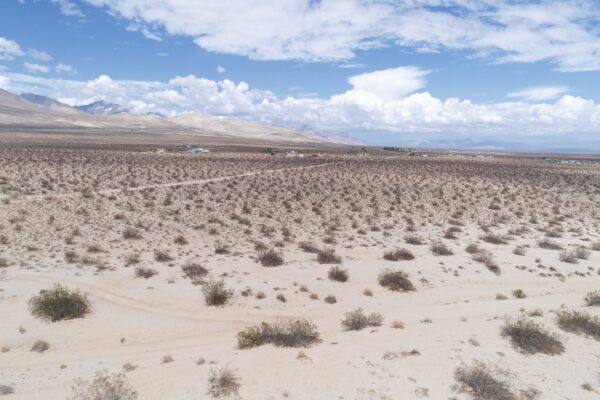
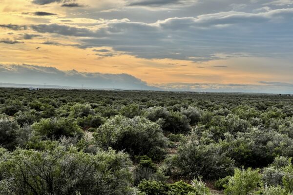
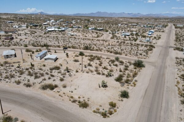
.24-ACRE GEM IN KLAMATH, OR

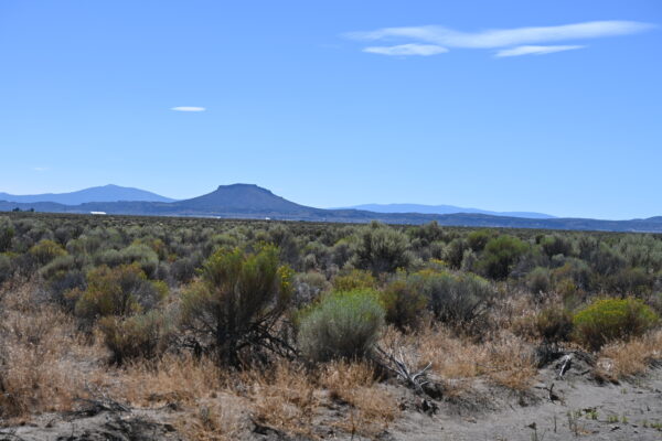
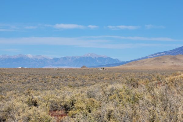
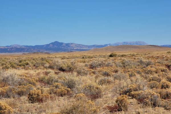
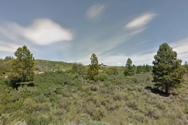
Nothing could compare with a home out in the countryside. If you think so too, then grab this 0.24-Acre gem in the lush Klamath County, OR. Sitting along Forest View Dr, this lot comes with an excellent road frontage and a short distance to the still waters of Agency Lake.

About 28 miles south of your location is the vibrant community of Klamath Falls. This city at the southernmost part of the state is home to the thrilling Klamath Falls rapids, verdant forest, and rangeland. With 300 days of sunshine, the forests offer an abundance of outdoor activities all year round. From hiking and water sports in the summer to winter sports like snowmobiling or skiing and snowboarding in the Cascade mountains.

Call us today.

Ask For More Information.

Pricing Details: $9,900 Cash

State: Oregon

County: Klamath

City: Klamath Falls

APN: R228257

Size: 0.24 acres

Center GPS: 42.565751, -121.919974


Nearest Landmarks:

Collier Logging Museum – 13 min (9.6 miles)

Fort Klamath Museum – 13 min (9.8 miles)

Crater Lake National Park – 14 min (9.4 miles)

Hagelstein County Park – 18 min (14.9 miles)

Fremont-Winema National Forest – 26 min (19.8 miles)

Spring Creek Headwaters – 27 min (16.3 miles)

Putnam’s Point – 29 min (26.1 miles)

Southern Pacific Steam Locomotive 2579 – 31 min (27.1 miles)

Crater Lake ZipLine – 35 min (32.2 miles)

Eagle Ridge County Park – 55 min (44.1 miles)


Ask For More Information.

Continue reading

15.28 acres in Kern County, California

Nestled in the middle of the Pacific Ocean to the West, Sequoia National Forest to the northwest and Death Valley National Forest to the northeast, this 15+ acre property is sitting and waiting. Away from the big city lights, you can see for miles and miles. This property sits outside of Bakersfield, CA in Kern County. 

Fun facts about Kern County: Kern is the number one oil and agriculture-producing county in the nation, with the second most diverse economy. Kern is the energy building capital and has a flourishing healthcare infrastructure.

What are you waiting for? This property is perfect for you so call us now to learn more of the offer!

Prop ID:
064-220-01-00-3
Size of Lot (or LOT AREA):
665,596 Sq. Ft.
Acreage Size:
15.28 ac
Tax Assessment Year:
2022
Yearly Taxes:
$117.27
Zone Type:
Estate 5 Acre Residential Suburban Mobile Home
Mobile Homes:
Yes, manufactured or mobile home 30 years or newer and must be on permanent foundation.
RV:
No camping. No RV’s allowed unless building a permanent home. 
Sewer:
Septic can be installed
Water:
Well would be required
Electricity:
Overhead power lines on Arugus and Palm. 
Terrain:
Property is level
Road Access:
Dirt, public maintained. 
Flood Zone:
No
HOA Information:
No information found
Abbreviated Legal Description:
SECTION 35 , TOWNSHIP 26 , RANGE 38 , QUARTER
GPS Coordinates:
 
Center:
35.625270, -117.856010
NW:
35.626540, -117.857210
NE:
35.626550, -117.854960
SW:
35.623810, -117.857180
SE:
35.623820, -117.854930

Continue reading

7 acres full of potential near Eufaula, OK

Come check out this wonderful property near Eufaula, Oklahoma. Sitting in Pittsburg County, this property has simple access to Eufaula Lake.

There is a rich native history, the county was formed from part of the Choctaw Nation in Indian Territory in 1907. There are no restrictions on this property and the wooded lots gives you a potential to have your own private homestead away from the city life. 

What are you waiting for? This property is perfect for you so call us now to learn more of the offer!

Prop ID:
2303-00-001-027-0-027-00
Size of Lot (or LOT AREA):
304,920 Sq. Ft.
Acreage Size:
7 ac
Tax Assessment Year:
2022
Yearly Taxes:
$22.00
Zone Type:
Rural Residential 
Mobile Homes:
Yes
RV:
No restrictions
Sewer:
Septic can be installed
Water:
Well would be required
Electricity:
Overhead Lines at south of the Property
Terrain:
Property is level
Road Access:
10th St.
Flood Zone:
No
HOA Information:
No information found
Abbreviated Legal Description:
LOTS 27, 28, 29, 30, 31, 32 & 33 BLK 1 KELSOE DEVELOPMENT 2
Complete Legal Description:
LOT:27-33 BLK:1 SUBD:KELSO #2 SEC/TWN/RNG/MER:SEC 34 TWN 9N RNG 17E LOTS 27, 28, 29, 30, 31, 32 & 33 BLK 1 KELSOE DEVELOPMENT 2
GPS Coordinates:
 
Center:
35.2111, -95.4868
NW:
35.2118, -95.4871
NE:
35.2118, -95.4865
SW:
35.2104, -95.4871
SE:
35.2104, -95.4864

Continue reading

Peaceful 10.27 acres near Reno, NV

Peaceful yet intriguing views await here in Washoe County, NV. This 10.27 acre property is level and ready for a new home or vacation retreat. This property is located in the Pyramid Lake Ranches subdivision, located just 24 minutes from the State Line Peak where Nevada and California meet. On the outskirts of the infamous Reno, this property provides a tranquil environment to someone wanting to escape the hustle and bustle of city life full-time or part-time.

What are you waiting for? This property is perfect for you so call us now to learn more of the offer!

Prop ID: 074-052-45

Acreage Size: 10.27 acres

Size of Lot (or LOT AREA): 447492 sq. ft.

Tax Assessment Year: 2022

Yearly Taxes: $35.13 each

Zoning: GR (General Rural)

Mobile Homes: HUD certified mobile homes allowed. Will need to contact the county for specifics on this requirement.

RV: Not allowed for living, but will be allowed during an active build permit. Will need to contact the county for specifics on this

requirement.

Sewer: Septic Needed

Water: Water will need to be hauled in, there is no source nearby.

Electricity: Solar Needed

Terrain: Level

Road Access: Dirt. Tahoe Ln. Cross street: Rainbow Rd and Honey Lake Way

Flood Zone: No

HOA: No information available

Abbreviated Legal Description: PYRAMID LAKE RANCHES 1 LT 45 (21-26-18)

GPS Coordinates:

Center: 40.1045, -119.9687

NW: 40.1053, -119.9696

NE: 40.1053, -119.9675

SW: 40.1035, -119.9697

SE: 40.1035, -119.9674

Continue reading

0.17 acres in Putnam County, FL

Quiet living awaits you on this quaint 0.17-acre property we have available in Putnam County, Florida. This property is close to Georges Lake and Etoniah Creek State Forest and just outside of Interlachen, FL, home to shops, stores and other significant foundations whenever the timing is ideal.

What are you waiting for? This property is perfect for you so call us now to learn more of the offer!

Prop ID 14-08-24-5100-0050-0070
Acreage Size 0.17 acres 
Size of Lot (or LOT AREA) 7405 sq. ft.
Tax Assessment Year 2022
Yearly Taxes $27.73 each
Mobile Homes Not Allowed
RV Allowed for 2 weeks at a time
Sewer Septic Needed
Water Well Needed
Electricity Overhead lines at Nassau & Duval ~167m
Terrain Level
Road Access Dirt, cross street Glade st & Manatee St.
Closest paved Road: Coral Farms Rd
Flood Zone No
HOA No information available
Abbreviated Legal Description LAKESIDE HILLS SEC 1 REPLAT 1 MB4 P121 BLK 5 LOT 7
   
GPS Coordinates:
Center: 29.7934, -81.8675
NW: 29.7936, -81.8676
NE: 29.7936, -81.8673
SW: 29.7933, -81.8676
SE: 29.7933, -81.8673

Continue reading

40 acres in Conejos County, CO

Ready for off-grid living? This would be the perfect spot to start. This 40 acre parcel has direct road access via County Rd 3.8 and 22 minutes to La Jara to stock up on all necessities before heading back home. With only a neighbor or two in the distance, this beautiful opportunity is sure to go quickly.  Standing in the center of this property, and looking West you are met with the mountains, with the closest peak being Chiquitos Peak, which is a steep hike, but worth the view. 
This wide-open space is bursting with opportunity, get ready to live off-grid while still having the city convenience a short drive away.


Prop ID 571703100020
Acreage Size 40 acres
Size of Lot (or LOT AREA) 1,742,400 sq. ft.
Tax Assessment Year 2021
Yearly Taxes $197.92
Mobile Homes MH’s are allowed, there is a permitting and inspection process.  They are the authorized authority by the State of Colorado Mobile Home Installation Program.  They must be installed per State Guidelines.  The County also requires a permit to place it on the property. Mobile homes would be best for full-time residential use. 
RV Yes, Seasonal RV camping is allowed.

RV’s must be licensed and registered with the Department of Motor Vehicle. You can stay in an RV while building a home if you have a valid building permit from Conejos County. 

Must have proper septic disposal and a legal water supply

Sewer Will need to install a septic. There is a permitting and inspection process. 
Water Will need to drill a well
Electricity Off-grid. No lines nearby. Solar or generator are both options. 
Terrain Gently Rolling
Road Access County Rd 3.8 is on the Eastern portion of the lot.
Flood Zone No
HOA No information available
Abbreviated Legal Description NW1/4 NE1/4 3-35-7 TNA 40 (LESS ROW & M R)
 
GPS Coordinates:
Center: 37.311656, -106.191678
NW: 37.313566, -106.194093
NE: 37.313588, -106.189563
SW: 37.309559, -106.194030
SE: 37.309612, -106.189522

Continue reading

20 acres near Christmas Valley in Lake County, OR

Presenting another wonderful 20 acres in the Oregon backcountry just 12 minutes from Christmas Valley. Beautiful views and wide open spaces wait for you here.
Just minutes southeast of town, this property offers the best of Christmas Valley living. This parcel provides access to almost endless hunting, fishing, and OHV opportunities. Build your home here with a Conditional Use Permit (CUP), and have all that Oregon’s High Desert has to offer right at your fingertips.
A Link to the Type II CUP can be found here: https://www.lakecountyor.org/government/docs/TYPE_II_CUP_APP.pdf
Property is only 12 minutes (6.1 miles) from Christmas Valley, where you can shop for your necessities. In town, you will find:
Chevron (gas station)
Fuel Commander Cardlock (gas station)
Sagewood Grocery
Gifts-n-more (restaurant)
Cardtronics ATM
The Trail Café
Handse Pump & Electric (garden center)
Robbins Equipment (Farm equipment supplier)
Are you a fan of golf? Christmas Valley Golf Course is nearby! The course has 3 sets of tees and challenging play for golfers for different skill levels. Enjoy fantastic views and well-groomed fairways.
Swimming and fishing? Baert Lake in Christmas Valley is open from Spring through Fall for fishing, swimming and boating. Ice Skating is available in the winter season!
A few miles away is the Summer Lake Wildlife Area, a refuge and breeding area of waterfowl, geese and swans and other water birds. Outdoor activities such as camping, picnicking, wildlife viewing and hunting are available. Stop by and relax at Summer Lake Hot Springs.
Nearby Fossil Lake is the #2 spot in all of North America for plant and animal fossils!
Nearby attractions:
Sand Dunes = 45 minutes
Summer Lake Wildlife Area = 35 minutes
Fossil Lake = 35 minutes
Approx. Travel Time:
Bend, OR = 2 1/2 hours
Portland, OR = 5-6 hours
Boise, ID = 5-6 hours


Prop ID:
3565
Size of Lot (or LOT AREA):
871,200 sq. ft.
Acreage Size:
20 acres
Tax Assessment Year:
2021
Yearly Taxes:
$71.55/Year
Zone Type:
A-2 Agriculture
Mobile Homes:
Mobile homes are typically not allowed. If it is newer than 1976, then you don’t need a CUP. If older than 1976 then you would need a CUP and it is not guaranteed. It would require a Type II CUP and then Building and Septic permits to get power and an address.
RV
Camping and RV’s are allowed for short periods of time, but not more than 7 out of 30 days for a guest of the owners. You cannot live on the property in an RV, and camping is only supposed to be for short periods like a weekend here or there.
Water
Can drill a well. Property is outside of the Christmas Valley Domestic Water District boundary. 
Sewer Septic can be installed. Composting toilets are only allowed if they are connected directly to an approved septic system.  
Electricity  Nearest power post is about 0.25 miles away from the lot.
Terrain:  Property is relatively flat.
Road Access:
The property has legal road access  through the Penn Philips platted roads. 
Flood Zone
None.
HOA
None.
Abbreviated Legal Description
SECTION 6 TOWNSHIP 27S RANGE 17E QUARTER PRCL 1100 MAPTAX LOT: 27S17E060110000
GPS Coordinates: 
Center:
43.261519, -120.751612
NW:
43.263361, -120.752829
NE:
43.263342, -120.750327
SW:
43.259697, -120.752843
SE:
43.259707, -120.750354

Continue reading

4.5 acres in Costilla County, CO

Don’t miss out on this great opportunity for private living in southern Colorado. Clear views of blue skies and mountainous ranges can be seen for miles all while being within a short drive is the Alamosa National Wildlife Refuge and Visitor Center and San Luis Regional Airport. The adjacent property is also available, reach out today for more information!


Prop ID:
703-97-830
Size of Lot (or LOT AREA):
196,471 sq. ft..
Acreage Size:
4.5103 acres
Tax Assessment Year:
2020
Yearly Taxes:
$134.16/Year
Zone Type:
Estate – Residential
Mobile Homes:
Site built home: 600 sq ft min. Manufactured homes are okay.
RV
Long-Term RV Camping Permits are valid for 60 Days and a new application must be filed before the expiration date of the permit. $200 fee – septic & water required). Long-term camping SHALL NOT EXCEED 180 DAYS per RV, Person, or Parcel in any 12 month period. RV’s must be inspected by the Planning and Zoning office to ensure all plumbing and electrical is in working order prior to application approval. Sites will be inspected prior to approval. ONLY ONE (1) RV SHALL BE PERMITTED PER PARCEL. 14 days of camping within a 3 month period. $250 fee – good for 90 days at a time while building, renew for up to 18 months. 
Water
Can drill a well. 
Sewer Septic can be installed. Composting toilets are only allowed if they are connected directly to an approved septic system.  
Electricity  No power lines nearby.
Terrain:  Property is rolling.
Road Access:
Property can be accessed via a dirt road on the Northern and Southern portions of the lot.
Flood Zone
None.
HOA
None.
Abbreviated Legal Description
S.L.V.R. UNIT 24 BLK 55 LOT 3 and 4
GPS Coordinates: 
Center:
37.338809, -105.684944
NW:
37.339613, -105.685510
NE:
37.339613, -105.684364
SW:
37.337993, -105.685525
SE:
37.337987, -105.684359

Continue reading

4.4 acres in Costilla County, CO

Don’t miss out on this great opportunity for private living in southern Colorado. Clear views of blue skies and mountainous ranges can be seen for miles all while being within a short drive is the Alamosa National Wildlife Refuge and Visitor Center and San Luis Regional Airport. The adjacent property is also available, reach out today for more information!


Prop ID:
703-97-820
Size of Lot (or LOT AREA):
192,815 sq. ft.
Acreage Size:
4.4264 acres
Tax Assessment Year:
2020
Yearly Taxes:
$134.16/Year
Zone Type:
Estate – Residential
Mobile Homes:
Site built home: 600 sq ft min. Manufactured homes are okay.
RV
Long-Term RV Camping Permits are valid for 60 Days and a new application must be filed before the expiration date of the permit. $200 fee – septic & water required). Long-term camping SHALL NOT EXCEED 180 DAYS per RV, Person, or Parcel in any 12 month period. RV’s must be inspected by the Planning and Zoning office to ensure all plumbing and electrical is in working order prior to application approval. Sites will be inspected prior to approval. ONLY ONE (1) RV SHALL BE PERMITTED PER PARCEL. 14 days of camping within a 3 month period. $250 fee – good for 90 days at a time while building, renew for up to 18 months. 
Water
Can drill a well. 
Sewer Septic can be installed. Composting toilets are only allowed if they are connected directly to an approved septic system.  
Electricity  No power lines nearby
Terrain:  Property is rolling.
Road Access:
Property can be accessed via a dirt road on the Northern and Southern portions of the lot.
Flood Zone
None.
HOA
None.
Abbreviated Legal Description
S.L.V.R. UNIT 24 BLK 55 LOT 3 and 4
GPS Coordinates: 
Center:
37.338814, -105.683783
NW:
37.339613, -105.684364
NE:
37.339616, -105.683244
SW:
37.337987, -105.684359
SE:
37.337988, -105.683239

Continue reading

0.25 acres in Meadview, AZ

This ¼ acre property located in Meadview, AZ is perfect for the adventurer looking to settle down in a low maintenance area with plenty to do. Located in northwest Arizona, on the Arizona side of Lake Mead, at the extreme western end of the Grand Canyon National Park. Perched on the Grapevine Mesa, a high desert plateau with elevations around 4,000′, and just south of Lake Mead. It has access to Lake Mead, the largest man made lake in the United States.
Meadview is the perfect hideaway with many recreational opportunities including boating, waterskiing, swimming, camping,hiking, and photography. Meadview is where the river rafts exit after their journey down the Colorado River through the Grand Canyon.


Prop ID:
343-23-080
Size of Lot (or LOT AREA):
10,890 sq. ft.
Acreage Size:
0.25 acres
Tax Assessment Year:
2021
Yearly Taxes:
$41.08/Year
Zone Type:
R1/10M
Mobile Homes:
Mobile homes are not listed in permitted use. The manufactured dwelling unit shall have been built after June 15, 1976 and be built to standards established by the U.S. Department of Housing and Urban Development.
Water
Water is nearby, along  Galloway and Ashley Drive but need to file an application in order to verify meter availability and get the quote.
Sewer Septic can be installed. $518.00 for the permit
Electricity  There are power posts along the Southern lotline of the lots.
Terrain:  Property is relatively flat.
Road Access:
Properties can be accessed via Galloway Dr.
GPS Coordinates: 
Center:
36.016091, -114.060276
N:
36.016201, -114.060478
E:
36.016244, -114.060112
S:
36.015887, -114.060377
W:
36.015942, -114.060113

Continue reading

© 2026 Liberty Land Sales. All Rights Reserved