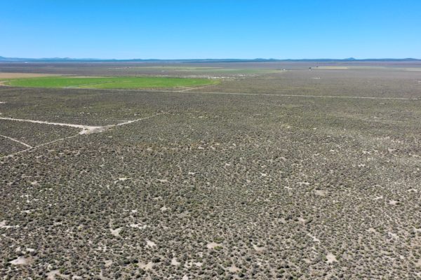
Beautiful 20 Acre Property Near BLM Land and the Highway!

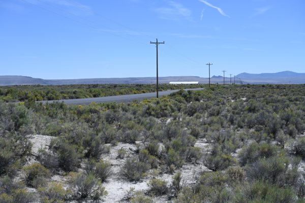
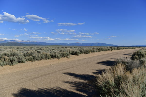
This parcel is near Christmas Valley Highway and BLM with good dirt road access. Only one parcel separates your property from BLM land and there is dirt road access to it! Lake County provides access to endless hunting, fishing, and OHV opportunities. Build your home with a Conditional Use Permit (CUP), and have all that Oregon’s High Desert has to offer right at your fingertips. This property is only 25 minutes away from CV!

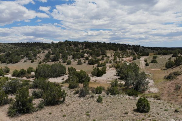
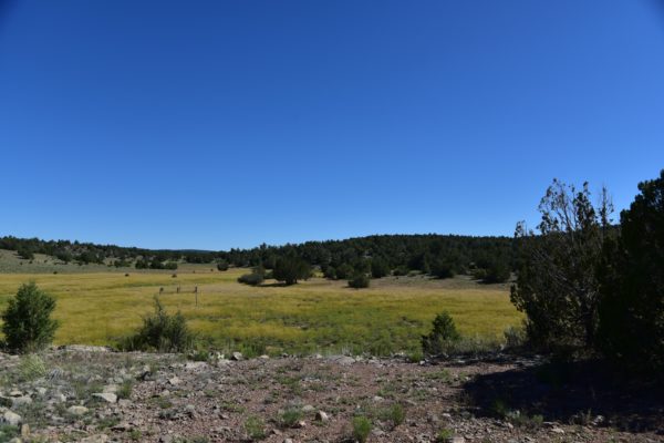
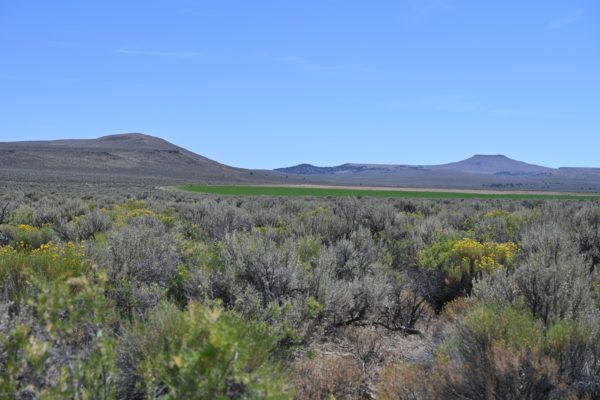
Escape large city life and enjoy wide-open spaces with fresh air, vast panoramic vistas and beautiful sunrises and sunsets.

Picture yourself living and playing on 20 acres in Lake County.

Become a land owner for an affordable monthly payment (or significant cash discount!) and enjoy your country living dreams. With dirt road access to the property, this lot is close to both the outdoor destination Christmas Valley Sand Dunes and the town of Christmas Valley. Christmas Valley offers the amenities of gas, groceries, restaurants, golf and more.

Start your day with vast vistas and sunrises. Spend your day building your off-grid dream or enjoying the outdoors adventure offered by Lake County, Oregon. Camp, hunt, or off-road on or near your own piece of land. Visit local natural wonders like Table Rock or Crack in the Ground, or spend the day riding waves of sand at Christmas Valley Sand Dunes.

APN: 7425

Annual Taxes: $100.11 (Current)

Zoning: A-2, would require a TYPE II CUP for it to be buildable.

Zone Type: The property is zoned A-2 Agriculture Use. A Type II CUP would be required for the property to become buildable, and it would likely be approved.

Mobile Homes: Mobile homes are not allowed without land use.

RV: Camping and RV’s are allowed for short periods of time, but not more than 7 out of 30 days for a guest of the owners. You cannot live on the property in an RV, and camping is only supposed to be for short periods of time.

Minimum Homes Size: 120 sq ft

Sewer: Septic can be installed.

Water: Can drill a well.

Electricity: Would be by alternative source, such as solar or generator.

Terrain: Property is gently rolling.

Road Access: Access is from the dirt road on the Southern portion of the property that leads to a road coming off of Christmas Valley HWY.

Flood Zone: No

HOA: No

Legal Description: E/2 of SW/4 of NE/4 of Section 26, Township 27 South, Range 21 East. Account Number 7425

GPS Coordinates:
Center: 43.203253, -120.161664
NW: 43.205011, -120.162865
NE: 43.205012, -120.160369
SW: 43.201457, -120.162809
SE: 43.201452, -120.160312

Continue reading

Beautiful Property in Huerfano County’s Rio Cucharas Phase #2

Imagine waking up to majestic mountain views and abundant wildlife, which makes this area such a wonderful place to live or visit. Add the fact that it is sunny more than 300 days per year, and you have an outdoor paradise.

Build a cabin, a house, park a mobile home or just bring out your RV and camp on your own property. Enjoy area recreational opportunities like hiking, biking, motocross, fishing, waterskiing, swimming and hunting during Spring, Summer and Fall seasons. Walsenburg Reservoir, Horseshoe Lake, Lake Oehm and Huerfano River and golf are only minutes away. And during the winter season, you are only 2.5 hours from Wolf Creek or Taos Ski areas.

Nearby Lathrop State Park’s two lakes offer a variety of boating and angling opportunities for all types of water recreation. Martin Lake offers water skiing, power and sail boating. Because Martin is a warm-water lake, it makes it great for swimmers. Horseshoe Lake is a peaceful haven for canoeists, kayakers, sailors and other boaters at wakeless speeds. Catfish, bass, walleye, trout and blue gill thrive in both lakes. Horseshoe Lake is known for its large tiger muskies. You can also go, Camping opportunities abound at Lathrop. Lathrop’s two campgrounds have 103 sites that can accommodate motor homes, trailers, and tents, and offer either a basic or improved camping experience. Lathrop is also the only Colorado State Park with a golf course: the 9-hole Walsenburg Golf Course.

Won’t last long at this price!

APN: 257981

Size: 3.93 Acres

Sewer: Would be by septic.

Water: Would be by well.

Power: Poles are four-tenths of a mile away (.4)

Zone Type: Rural Residential (RR)

Mobile Homes: Manufactured homes are allowed, qualified and non-qualified: A single-wide or double-wide factory manufactured home or otherwise a non-qualified manufactured home and was constructed after 1992. They are to be set on a permanent foundation and are consider a residential dwelling. You can only have one dwelling on a tract of land an RR district.

RVs: Tent, campers and recreational vehicles, when employed as temporary residences for human occupation, are hereby declared to be a temporary use as defined within these regulations and shall be treated as other temporary buildings and uses. Tents and campers is allowed as temporary residences for a period of more than seven (7) days within any thirty (30) day period.

Minimum Home Size Required: 600 square feet

Terrain: Property is rolling.

Road Access: Property can be access via La Deora Blvd.

Flood Zone: No flood data available.

HOA: No HOA/POA for RIO CUCHARAS.

Annual Taxes: $81.84 (Current)

Legal Description: Lot 592, Rio Cucharas Phase 2, County of Huerfano, State of Colorado, Schedule #361855.

GPS Coordinates:
Center: 37.653553, -104.854926
North:   37.653843, -104.856005
East:     37.653808, -104.853172
South:   37.652923, -104.855109
West:    37.653050, -104.854353


Continue reading

Beautiful Lot in Costilla County, CO

Legal Description: Lot 4755 of Block 224 of Sangre de Cristo Ranches, Unit K-2, according to the plat thereof recorded in the Office of the Clerk and Recorder of Costilla County, San Luis, Colorado.

Continue reading

Beautiful Lot Just Waiting For You To Build Your Riverview Home!

Ready to build your dream home overlooking the Powell River, with amenities but LOW HOA fees? Then this property is for you! The Deerfield Resort subdivision is located in LaFolle, TN with great proximity to Knoxville (40 mins), Chattanooga (2 hrs 15 mins) and Nashville (3 hours 15 mins). Amenities in this community include, a pool, tennis courts, a volleyball court, the lake and more! HOA membership is $250 per year for the amenities and road maintenance, plus $200 per year for security.

This lot can be built on and would have an amazing lake view.

APN Parcel Number: 114A A 022.00

Lot Area (Sq ft): 54,450 sq ft

Lot Acreage: 1.25 Acres

Yearly Property Taxes: $129.00 (Current)

HOA Fees: $200 per year for security, plus $250 per year for road maintenance and access to amenities, including the pool, tennis courts, playground and volley ball. Boat slips available at the marina. https://www.deerfieldresort.com/

Zoning: Residential

Water: Operated by Deerfield Water System – Scott Fields. $500 one time fee to tie in for new construction. $70 for up to 6,000 gallons, $.005 per gallon after that. Billed quarterly.

Sewer: Would need septic.

Power: Posts on opposite lot. Served by La Follette Utilities.

RV’s / Mobile Homes: There shall be no trailers, buses, mobile homes, double-wide mobile homes, tents, campers, shacks or any derivative of the foregoing, or any structure removed from any other location or site, situated on any tract or lot as a temporary or permanent residence or for storage. Either temporary or permanently. Operators of any recreational vehicles, such as golf carts and off- road vehicles must be 16 years or older and have a valid driver’s license.

Pre-Fab Homes: Allowed, but new pre-fabricated homes or manufactured homes constructed elsewhere and moved into the subdivision, must be approved by the Developer prior to construction and moved into the subdivision on a semi-truck-not axels-and placed on a permanent foundation and has the appearance of an in-place built dwelling. The roof pitch must be at least 7 pitch. Homes must be at least 1,000 living space on main floor.

Terrain: Sloped. Buildable.

Access: Deerfield Way.

Legal Description: Situate in the Second (2nd) Civil District of Campbell County, Tennessee, and in the Deerfield Resort Area, and more particularly described as follows:

Being all of Lot Number Twenty Three (23) as set forth on Plat prepared by Jerry W. Crutchfield, R.L.S. #1612, dated March 18, 2002, and revised on May 21, 2003, of record in Plat Cabinet A, Slide 500, in the Register’s Office for Campbell County, Tennessee.

Flood Zone: Not in a flood zone.

GPS Coordinates:
Center: 36.328089, -84.003782
NW: 36.328506, -84.004097
NE: 36.328105, -84.003197
SW: 36.328007, -84.004292
SE: 36.327708, -84.003406

Continue reading

Awesome 10 Acre Hunting Property Bordering State Land!

Get ready for your ultimate getaway or second home property! What could be better than a 10 acre lot that borders state land, is accessible by dirt road, but with proximity to historic Route 66 with rolling hills and trees? As you can see from the photos, you can definitely get a camper up here!

This property is just south of route 19 that runs from Kingman to Flagstaff. It is off the beaten path, but still accessible. State land shares a border with this parcel to the west.

These photos and video were taken May 28, 2020.

  • Prop ID: 301-30-052F
  • Size: 10 Acres
  • Zoning: RCU-2A
  • Address: Near Peach Springs, AZ 86434
  • Annual Taxes: $140.18 (Current)
  • Mobile Homes: Allowed, with primary residence established, for travel trailer.
  • RV: You can camp on the property 10 days at a time, one month between camping trips, three times a year. Can apply for temporary dwelling permit to live in RV while SFR is being built.
  • Septic: Would need to be installed
  • Water: Would need to be hauled or well drilled.
    Electricity: Off grid. No power lines nearby.
    Terrain: Property is rolling.
    Road Access:
    Nearest access to the property would be by an unnamed dirt road on the West. There is an easement between the lot west of this property and this property. Also, lot borders state owned land to the North.
    Flood Zone: The parcel are located in FEMA Zone D, which means that the area has not been study for flood hazards.
    HOA: None
    Abbreviated Legal Description: A rectangular portion being the NE4NW4NW4 of said section AKA NE4 of Parcel 645 of Green View Ranches Contains 10.00 acres.
    Complete Legal Desc: The Northeast Quarter of the Northwest Quarter of the Northwest Quarter of Sec 11 T24N R10W of the Gila and Salt River Base and Meridian, Yavapai County Arizona aka Northeast Quarter of Parcel 645 Green View Ranches.
    GPS Coordinates:
    Center: 35.486771, -113.307559
    NW: 35.487694, -113.308634
    NE: 35.487686, -113.306448
    SW: 35.485869, -113.308653

    SE:                   35.485861, -113.306431

Continue reading

**Amazing 10 Acre Getaway Lot Bordering Public Land!**

Get ready for your ultimate getaway or second home property! What could be better than a 10 acre lot that borders state land, is accessible by dirt road, but with proximity to historic Route 66 with rolling hills and trees? As you can see from the photos, you can definitely get a camper up here!

This property is just south of route 19 that runs from Kingman to Flagstaff. It is off the beaten path, but still accessible. State land shares a border with this parcel to the west.

These photos and video were taken May 28, 2020.

  • Prop ID: 301-30-052E
  • Size: 10 Acres
  • Zoning: RCU-2A
  • Address: Near Peach Springs, AZ 86434
  • Annual Taxes: $140.18 (Current)
  • Mobile Homes: Allowed, with primary residence established, for travel trailer.
  • RV: You can camp on the property 10 days at a time, one month between camping trips, three times a year. Can apply for temporary dwelling permit to live in RV while SFR is being built.
  • Septic: Would need to be installed
  • Water: Would need to be hauled or well drilled.
    Electricity: Off grid. No power lines nearby.
    Terrain: Property is rolling.
    Road Access:
    Nearest access to the property would be by an unnamed dirt road on the West. There is an easement between the lot west of this property and this property. Also, lot borders state owned land to the North.
    Flood Zone: The parcel are located in FEMA Zone D, which means that the area has not been study for flood hazards.
    HOA: None
    Abbreviated Legal Description: A rectangular portion being the NE4NW4NW4 of said section AKA NE4 of Parcel 645 of Green View Ranches Contains 10.00 acres.
    Complete Legal Desc: The Northeast Quarter of the Northwest Quarter of the Northwest Quarter of Sec 11 T24N R10W of the Gila and Salt River Base and Meridian, Yavapai County Arizona aka Northeast Quarter of Parcel 645 Green View Ranches.
    GPS Coordinates:
    Center: 35.486771, -113.307559
    NW: 35.487694, -113.308634
    NE: 35.487686, -113.306448
    SW: 35.485869, -113.308653

    SE:                   35.485861, -113.306431


Continue reading

More Than 7 Acres To Call Your Own – Close to the Sand Dunes!

Imagine your own 7+ acres in the Oregon backcountry just 15 minutes from Christmas Valley. It has access from a good dirt road and is close to the Sand Dunes! Dunes are only 4 miles away. It has beautiful views.

Just minutes southeast of town, this property offers the best of Christmas Valley living. This parcel provides access to almost endless hunting, fishing, and OHV opportunities. Build your home here with a Conditional Use Permit (CUP), and have all that Oregon’s High Desert has to offer right at your fingertips.

A Link to the Type II CUP can be found here: https://www.lakecountyor.org/government/docs/TYPE_II_CUP_APP.pdf

Property is only 20 minutes (18 miles) from Christmas Valley, where you can shop for your necessities. In town, you will find:

  • Chevron (gas station)
  • Fuel Commander Cardlock (gas station)
  • Sagewood Grocery
  • Gifts-n-more (restaurant)
  • Cardtronics ATM
  • The Trail Café
  • Handse Pump & Electric (garden center)
  • Robbins Equipment (Farm equipment supplier)

Are you a fan of golf? Christmas Valley Golf Course is nearby! The course has 3 sets of tees and challenging play for golfers for different skill levels. Enjoy fantastic views and well-groomed fairways.

Swimming and fishing? Baert Lake in Christmas Valley is open from Spring through Fall for fishing, swimming and boating. Ice Skating is available in the winter season!

A few miles away is the Summer Lake Wildlife Area, a refuge and breeding area of waterfowl, geese and swans and other water birds. Outdoor activities such as camping, picnicking, wildlife viewing and hunting are available. Stop by and relax at Summer Lake Hot Springs.

Nearby Fossil Lake is the #2 spot in all of North America for plant and animal fossils!

Nearby attractions:

  • Sand Dunes = 45 minutes
  • Summer Lake Wildlife Area = 35 minutes
  • Fossil Lake = 35 minutes

Approx. Travel Time:

  • Bend, OR = 2 1/2 hours
  • Portland, OR = 5-6 hours
  • Boise, ID = 5-6 hours

Parcel Number: 16484

Size: 7.38

Yearly Taxes: $54.32 (Current)

Zoning: A-2 Agricultural Use. It would require a Type II Conditional Use Permit to have a home built.

Mobile Homes: Mobile Homes are allowed if permitted through a Land Use process for the establishment of a dwelling, and after septic and building permits. It can be permanent placement if qualifying as a manufactured home through the building department.

RV:  Yes. RV’s are allowed when camping, but should not be left on the property if you are not there. Can be used without a permit for short periods of time – 7 days out of 30. Longer periods require a permit.

Sewer: Would be by septic.

Water: Would be by well.

Electricity: Power is .4 mile from property.

Terrain: Property is almost flat.

Road Access: Access from dirt road at northern boundary of property, which connects to paved road.

Flood Zone: No

HOA: No HOA

Complete Legal Desc:

Account No. 2619 4-2200 Reference No. 16484 Sale No. 1928 Twp. 26 South, Range 19 EWM., Sec. 4: W1/2SE1/4 Gov’t Lot 3

GPS Coordinates:

Center: 43.351542, -120.474170

NW:      43.352905, -120.474794

NE:       43.352904, -120.473553

SW:       43.352904, -120.473553

SE:       43.350213, -120.474829

Continue reading

8 Minutes to Town, Close to Paved Road!

Imagine your own 20 acres in the Oregon backcountry just 8 minutes from Christmas Valley. It has access from a good dirt road and is close to S. Fandango Road. It has beautiful views.

Just minutes southeast of town, this property offers the best of Christmas Valley living. This parcel provides access to almost endless hunting, fishing, and OHV opportunities. Build your home here with a Conditional Use Permit (CUP), and have all that Oregon’s High Desert has to offer right at your fingertips.

A Link to the Type II CUP can be found here: https://www.lakecountyor.org/government/docs/TYPE_II_CUP_APP.pdf

Property is only 8 minutes (5.5 miles) from Christmas Valley, where you can shop for your necessities. In town, you will find:

  • Chevron (gas station)
  • Fuel Commander Cardlock (gas station)
  • Sagewood Grocery
  • Gifts-n-more (restaurant)
  • Cardtronics ATM
  • The Trail Café
  • Handse Pump & Electric (garden center)
  • Robbins Equipment (Farm equipment supplier)

Are you a fan of golf? Christmas Valley Golf Course is nearby! The course has 3 sets of tees and challenging play for golfers for different skill levels. Enjoy fantastic views and well-groomed fairways.

Swimming and fishing? Baert Lake in Christmas Valley is open from Spring through Fall for fishing, swimming and boating. Ice Skating is available in the winter season!

A few miles away is the Summer Lake Wildlife Area, a refuge and breeding area of waterfowl, geese and swans and other water birds. Outdoor activities such as camping, picnicking, wildlife viewing and hunting are available. Stop by and relax at Summer Lake Hot Springs.

Nearby Fossil Lake is the #2 spot in all of North America for plant and animal fossils!

Nearby attractions:

  • Sand Dunes = 45 minutes
  • Summer Lake Wildlife Area = 35 minutes
  • Fossil Lake = 35 minutes

Approx. Travel Time:

  • Bend, OR = 2 1/2 hours
  • Portland, OR = 5-6 hours
  • Boise, ID = 5-6 hours

Parcel Number: 7214

Size: 20.00

Yearly Taxes: $69.76 (Current)

Zoning: A-2 Agricultural Use. It would require a Type II Conditional Use Permit to have a home built.

Mobile Homes: Mobile Homes are allowed if permitted through a Land Use process for the establishment of a dwelling, and after septic and building permits. It can be permanent placement if qualifying as a manufactured home through the building department.

RV:  Yes. RV’s are allowed when camping, but should not be left on the property if you are not there. Can be used without a permit for short periods of time – 7 days out of 30. Longer periods require a permit.

Sewer: Would be by septic.

Water: Would be by well.

Electricity: Power is 3/4 mile from property.

Terrain: Property is gently rolling.

Road Access: Access from dirt road at northern boundary of property, which connects to Fandango Road.

Flood Zone: No

HOA: No HOA

Complete Legal Desc:

The West ½ of the Northeast ¼ of the Northeast ¼ of Section 21, Township 27 South, Range 18 East of the Willamette Meridian.

RESERVING THEREFROM an easement of 30 feet along all boundaries for public highway for use in common with others, with power to dedicate, and EXCEPTING THEREFROM all petroleum, oil, minerals, and products derived therefrom, within or underlying said land or that may be produced therefrom and all rights thereto.

THE GRANTOR HEREBY RESERVES a right of way, with right of entry upon, over, under, along , across and through the said land for the purpose of erecting, constructing, operating, repairing and maintaining pole lines with cross arms for the transmission of electrical energy, and for telephone lines and/or for laying, repairing, operating and renewing any pipe line or lines for water, gas or sewage, and any conduits for electric or telephone wires, and reserving to the Grantor the sole right to convey the rights hereby reserved.

GPS Coordinates:

Center: 43.221068, -120.585556

NW:      43.222977, -120.586847

NE:       43.222973, -120.584374

SW:      43.219312, -120.586848

SE:       43.219305, -120.584374

Continue reading

19.11 Acre Corner Lot Off Main Road, Power Poles on Road, <10 Mins from Town

Imagine your own 20 acres in the Oregon backcountry less than 10 minutes from Christmas Valley.

Just minutes southwest of town, this property offers the best of Christmas Valley living. This parcel provides access to almost endless hunting, fishing, and OHV opportunities. Build your home here with a Conditional Use Permit (CUP), and have all that Oregon’s High Desert has to offer right at your fingertips. Power poles are right on the road!

A Link to the Type II CUP can be found here: https://www.lakecountyor.org/government/docs/TYPE_II_CUP_APP.pdf

Property is only 9 minutes (7.2 miles) from Christmas Valley, where you can shop for your necessities. In town, you will find:

  • Chevron (gas station)
  • Fuel Commander Cardlock (gas station)
  • Sagewood Grocery
  • Gifts-n-more (restaurant)
  • Cardtronics ATM
  • The Trail Café
  • Handse Pump & Electric (garden center)
  • Robbins Equipment (Farm equipment supplier)

Are you a fan of golf? Christmas Valley Golf Course is nearby! The course has 3 sets of tees and challenging play for golfers for different skill levels. Enjoy fantastic views and well-groomed fairways.

Swimming and fishing? Baert Lake in Christmas Valley is open from Spring through Fall for fishing, swimming and boating. Ice Skating is available in the winter season!

A few miles away is the Summer Lake Wildlife Area, a refuge and breeding area of waterfowl, geese and swans and other water birds. Outdoor activities such as camping, picnicking, wildlife viewing and hunting are available. Stop by and relax at Summer Lake Hot Springs.

Nearby Fossil Lake is the #2 spot in all of North America for plant and animal fossils!

Nearby attractions:

  • Sand Dunes = 45 minutes
  • Summer Lake Wildlife Area = 35 minutes
  • Fossil Lake = 35 minutes

Approx. Travel Time:

  • Bend, OR = 2 1/2 hours
    Portland, OR = 5-6 hours
    Boise, ID = 5-6 hours

Parcel Number: 2923

Size: 19.11

Yearly Taxes: $85.91 (Current)

Zoning: A-2 Agricultural Use. It would require a Type II Conditional Use Permit to have a home built.

Mobile Homes: Mobile Homes are allowed if permitted through a Land Use process for the establishment of a dwelling, and after septic and building permits. It can be permanent placement if qualifying as a manufactured home through the building department.

RV:  Yes. RV’s are allowed when camping, but should not be left on the property if you are not there. Can be used without a permit for short periods of time – 7 days out of 30. Longer periods require a permit.

Sewer: Would be by septic.

Water: Would be by well.

Electricity: Power Pole on Oil Dri Road also known as Kitty Litter Road.

Terrain: Property is gently rolling.

Road Access: Access from Oil Dri Road also known as Kitty Litter Road.

Flood Zone: No

HOA: No HOA

Complete Legal Desc:

The East Half of the Northeast Quarter of the Southeast Quarter of Section 15, Township 27 South, Range 16, East of the Willamette Meridian, EXCEPT the East 15 feet of the East Half of the Northeast Quarter of the Southeast Quarter of Section 15, Township 27 South, Range 16, East of the Willamette Meridian.

GPS Coordinates:

Center: 43.226603, -120.801118

NW: 43.228386, -120.802271

NE: 43.228375, -120.799888

SW: 43.224756, -120.802323

SE: 43.224739, -120.799962

Continue reading

Great Lot A Few Blocks from Hwy 159 -Assessed at $7900! San Luis, CO

Are you ready to escape crowded urban areas and look at this view every day? Build your cabin here and enjoy the tranquility of nature with beautiful mountain views. Not wanting to build? Manufactured homes are ok! (600 sq ft or bigger, newer than 1976)

This property is very close to Highway 159, just a few miles away from the town of Sanford, CO and minutes from San Luis. Few miles North of the property is the majestic Blanca Peak, the fourth highest summit of the Rocky Mountains an amazing location for camping and hiking.

The Costilla County Assessor values this parcel at $7,900!

Parcel Number: 707-11-520

Size: 4.48 Acres

Zoning: Residential

GPS Coordinates:

  • Center Point: 37.2598575912296,-105.436376060627
  • NW Corner: 37.2598623375363,-105.438490865424
  • SW Corner: 37.2589931929479,-105.438499755412
  • SE Corner: 37.2589884280745,-105.436377056047
  • NE Corner: 37.2598575912296,-105.436376060627

Power lines: Mobile/Satellite/Alternative

Septic: Septic or Alternative System

Water: Would be by well or Alternative System

Access: Property can be accessed via Coronado Road.

Flood Zone: No

RV: Long-Term RV Camping Permits are valid for 60 Days (new application must be filed before the expiration date of the permit. $200 fee – septic & water required. Long-term camping SHALL NOT EXCEED 180 DAYS per RV, Person, or Parcel in any 12 month period. RV’s must be inspected by the Planning and Zoning office to ensure all plumbing and electrical is in working order prior to application approval. Sites will be inspected prior to approval. ONLY ONE (1) RV SHALL BE PERMITTED PER PARCEL. 14 days of camping within a 3 month period. $250 fee – good for 90 days at a time while building, renew for up to 18 months.)

Mobile homes: Site built home 600sqft min, manufactured homes are okay.

Taxes: $120.44

Legal Description: S.L.N.E. FILING 2 BLK 5 LOT 9 FR. SCH. 70700130 


Continue reading

© 2026 Liberty Land Sales. All Rights Reserved