25 Acre Hunter’s Utopia-With Power-$250/mo

Great Hunting Property Southern Colorado-25 Acres|APN3090

Another fantastic property from Mile High Rural Land.

Seller Financing: $5,000 down, $250/mo, 84 mo. 0%.

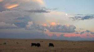
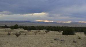
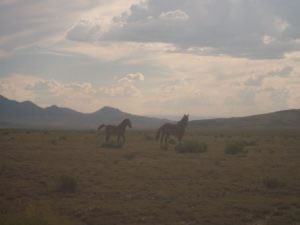
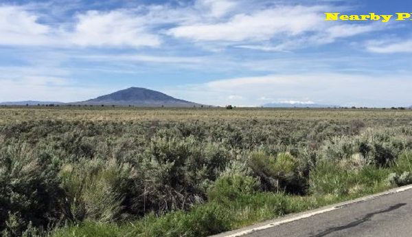
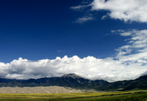
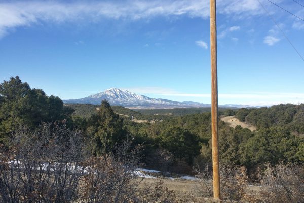
Escape to total tranquility. This 25-acre parcel features rolling hills terrain with Pinon and Cedar trees. There are some nice flat areas perfect to build a hunting cabin, park a tiny home or a container home This property has phenomenal hunting habitat. With the many Deer, Antelope and Elk, along with the smaller game in the area, this is a hunters paradise. This property also has excellent access and power lines running along the road.

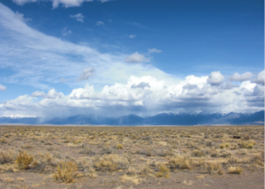
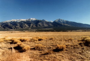
Or, if you prefer to not have any neighbors, this is a perfect property for that. No covenants, no restrictions and beautiful views all around. Bring your RV and camp on your own property. Enjoy Colorado’s over 300 days of sunshine by day and stargaze at night.

You may also enjoy this for your own private land for riding motorcycles and ATV’s.

Some nearby attractions are the towns of La Veta and Walsenburg, as well as many points of interest. From many 14 hikes to lakes and rivers for fishing and summer recreation, the Great Sand Dunes near Alamosa. So many things to do.

GPS: 37.490185, -104.692781 (past these coordinates into google maps)

https://www.google.com/maps/place/37°29’24.7″N 104°41’34.0″W/@37.4898485,-104.6947031,427m/data=!3m1!1e3!4m5!3m4!1s0x0:0x0!8m2!3d37.490185!4d-104.692781

Won’t last long at this price!

Seller Name: Mile High Rural Land

Seller Phone: 866-707-DIRT (3478)

Seller Email: [email protected]

Size (Acres): 25

APN: 30970

Legal Description: Map Ref: 28526130400030 Abbreviated Description: SUBD:RURAL AG PROPERTIES SEC 29-29-65 PT OF NW4SE4 25A 280-156 281-212 414-132-133 401294 401295 MAP REF:28526130400030

State: Colorado, County: Huerfano

Conveyance Document: Special Warranty Deed

General Elevation: 7500 ft

Zoning: Rural residential

Power: At road. Call San Isabel Electric 800-279-7432 for hook up estimate

Water: would be by well or tank delivery.

Sewer: would be by septic.

Roads: Dirt

Property Tax: $32.82

Association Dues: NA

Time Limit to Build: NA

Type of Terrain: Rolling

Closing/Doc. Fees: $299.00

Comparable properties: *Nearly all comps were 35 AC or larger

35 Acres, $29,999 http://www.landwatch.com/Huerfano-County-Colorado-Land-for-sale/pid/3928045

35 Acres, $45,000http://www.landwatch.com/Huerfano-County-Colorado-Land-for-sale/pid/3970701

35 Acres, $47,000 http://www.zillow.com/homes/for_sale/Huerfano-County-CO/land_type/2100147137_zpid/2350_rid/globalrelevanceex_sort/37.7433,-104.554482,37.400437,-105.275459_rect/10_zm/1_rs/

Information Resources

County Code Enforcement http://www.huerfano.us/Code_of_the_West.php

County Land Use http://www.huerfano.us/Building_Inspector_Info.php

Huntscore.com https://huntscore.com/hunts/co/deer/a5da2a9e-d96c-4506-b714-754daac5b836

About the Seller: Mile High Rural Land is a property investment company that prides itself on quick, professional, easy transactions. We are a family owned company and take pride in individualized attention and customer satisfaction.

We buy and sell land quickly at wholesale prices but sell to anyone. We operate this business from our home in Boulder Colorado, utilizing technology and operating 100% online to keep our costs down and pass the savings onto our buyers.

Continue reading

Pristine Ranch Land-160 Acres, Chaves County NM APN4151022264067

Ever dream of owning a large ranch? Here you go. 160 acres of pristine ranch land in New Mexico, about 2 hr north of Roswell. The Pecos river is only a short walk.

Property Location:

Chaves County NM

Latitude/Longitude Coordinates:

NW Corner: 33.951627, -104.261038

SW Corner: 33.948110, -104.260923

NE Corner: 33.951606, -104.243740

SE Corner: 33.948089 , -104.243740

We have bought this property right, so we can in turn pass the savings onto the buyer for a quick sale. If you check the Comps below, you will find the last one at $248/acre. This property is the closest in proximity and similar in features, except not so close to the Pecos River as ours is.

New Mexico has a huge range of outdoor activity, due to having six of the earth’s seven climatic zones and mountain ranges that tower over its high desert plains. To the north, 13,000 foot peaks covered in aspen and coniferous forests are covered in powdery snow, offering some of the finest ski conditions in the West. Taos Ski Valley has 110 runs, half of which are designated expert, and it remains a purist place only for alpine skiers. For snowboarding and skiing, try the Red River Ski Area, with over 290 acres and an average annual snowfall of 252 inches. In the nearby Enchanted Forest, there are 35 kilometers of groomed trails for Nordic skiing. From this Alpine Zone down to the southern Lower Sonoran Zone, there’s a great variety of game: deer, elk, quail, pheasants, waterfowl, pronghorn and javelina, just to name a few. Fishing is a year-round affair for most of New Mexico’s waters, excellent for panfish, trout, northern pike and walleye, and incredibly, there’s also ice fishing up north! With 310 days of sunshine a year, New Mexico is a paradise for golf lovers. There’s year-round golf available amongst the mountains, forests and deserts. This desert country will continue to surprise with its 30 major lakes and 10 major rivers, with rafters daring the Rio Grande west of Taos or opting for the Rio Chama for a calmer ride.

Comparables:

80 Acres (under contract), $64,000 http://www.landwatch.com/Chaves-County-New-Mexico-Land-for-sale/pid/326126654

151 Acres (for sale), $123,000 http://www.landwatch.com/Chaves-County-New-Mexico-Land-for-sale/pid/323541688

160 Acres (for sale), $125,000 http://www.landwatch.com/Chaves-County-New-Mexico-Land-for-sale/pid/323541687

69.5 Acres (for sale), $155,000 http://www.landwatch.com/Chaves-County-New-Mexico-Land-for-sale/pid/2694862

320 Acres (for sale), $79,500 (248/acre) http://www.zillow.com/homes/for_sale/Chaves-County-NM/fsba,fsbo_lt/land_type/2102961691_zpid/931_rid/20000-245000_price/70-857_mp/globalrelevanceex_sort/34.639987,-101.549378,31.949831,-107.3172_rect/7_zm/0_mmm/

Continue reading

Bring your Motorcycle or ATV! 47AC|APN13676420

A perfect 47AC property in Las Animas, CO that would probably catch your attention and will make this area such a wonderful place to live, to visit or even to have a vacation.

Hunters Paradise, no neighbors nor restrictions. This parcel is beautiful but very remote. However, it has excellent road access. If you don’t want anyone to bother you and have a 4WD, like to hunt or ride ATVs and motorcycles or just shoot your guns, then this is the place for you.

There are several cabins nearby and the property is on a county maintained access road.

Won’t last long at this price!

15% (2,699) discount off the terms price if paid off in 24 months or less.

*Customized terms packages available. Call us!

Seller Name: Mile High Rural Land

Seller Phone: 866-707-DIRT (3478)

Seller Email: [email protected]

Contact Website or Check Out:

Conveyance Document: Special Warranty Deed

Zoning: Rural residential

Power: By alternative means or you may call Southeast Colorado Power-La Junta Office(719) 384-2551 for estimates

Water: Tap or well. For specific details, please call local water drillers or call Weber Water Well Drilling & Pump Service, LLC at 719-738-2400

Sewer: would be by septic.

Roads: Dirt

Association Dues: NA

Time Limit to Build: NA

Type of Terrain: Flat

Closing/Doc. Fees: $299

Comparable Properties:

40AC-$14,000

http://www.landwatch.com/Las-Animas-County-Colorado-Land-for-sale/pid/25057799

40AC- $12,500

http://www.landwatch.com/Las-Animas-County-Colorado-Land-for-sale/pid/25056199

41AC-$12, 995

http://www.landwatch.com/Las-Animas-County-Colorado-Land-for-sale/pid/25056744

Local Attractions

Spanish Peak

This property has fantastic views of the wonderful Spanish Peaks in Southeastern Colorado. This property has a direct access to County Road 64.8 that allows 365 days a year access to your own land with mule deer, antelope and abundant small game. You also have great access to the Apishapa River and the millions of acres of public lands to the west in the wonderful mountains of Colorado. Drive four wheelers, shoot guns, hunt, and just enjoy the peace and quiet of owning your own 40 acres of Colorado.

Trinidad Lake State Park

If you want to spend some time with your family you can visit the Trinidad Lake State Park. The park is just an hour drive west of Trinidad and this park is also near to the Trinidad Lake a dammed reservoir. You can enjoy many activities in this park. Trinidad Lake State Park a great off-season vacation destination. There are hiking trails, and camping and boating opportunities. The property is just 43 miles from the Levsa Canyon.

http://www.landwatch.com/Las-Animas-County-Colorado-Land-for-sale/pid/25057799

http://www.landwatch.com/Las-Animas-County-Colorado-Land-for-sale/pid/25056199

http://www.landwatch.com/Las-Animas-County-Colorado-Land-for-sale/pid/25056744

About the Seller: Milehighruralland.com is a property investment company that prides itself on quick, professional, easy transactions. We are a family owned company and take pride on individualized attention and customer satisfaction.

We buy and sell land quickly at wholesale prices, but sell to anyone. We operate this business from our home in Boulder Colorado, utilizing technology and operating 100% online to keep our costs down and pass the savings onto our buyers.

Continue reading

Holiday Season Special: Great for Hunting and Camping

All in one place! If you are a nature lover, Wilderness Ranches in Moffat County is the right place for you. Experience the beauty of nature and experience the goodness it may offer with its beautiful green surroundings.

Bring your family and friends and enjoy the adventure that awaits you here. Grab your favorite fly fishing rod and reel, and head out to OVO Reservoir, Elk Lake Dam, Spring Creek and Box Spring Creek just a few miles away from your property. You can visit the brilliant Little Emerson Peak and Jim Robertson Mountain that can be found in Bakers Peak, hunt while you hike and camp in those beautiful mountains. Or, if you are a hunter, this area offers abundant hunting opportunities for all kinds of game.

This lot features lush landscape with a grassy meadow, trees, and shrubs. Great wildlife habitat.

Won’t last long at this price!

Cash Only: $1,997.00

Seller Name: Mile High Rural Land

Seller Phone: 866-707-DIRT (3478)

Seller Email: [email protected]

Local Attractions:

Many outdoor places for Hunting, Fishing, Snowmobiling, Motorcycling, 4 Wheeling, Bird watching, Hiking

Home

Gates of Lodore
The Gates of Lodore is the scenic entrance to the Canyon of Lodore, a canyon on the Green River in northwestern Colorado, United States. The name Gates of Lodore has become synonymous with the canyon itself and the two names are used interchangeably. The Canyon commences as the Green River departs Browns Park and cuts through the Uinta Mountains meandering eighteen miles until its end at Echo Park (Colorado), the confluence of the Green and Yampa River. It was named by the Powell Expedition after the English poem Cataract of Lodore.[3] It is located in Dinosaur National Monument.

Museum of Northwest Colorado
The Museum of Northwest Colorado, located in Craig, Colorado, was established in 1964 as the Moffat County Museum to house artifacts and preserve legends of the Old West.The museum features a large cowboy gear collection, including chaps, spurs, saddles, gun leather, guns and other artifacts. The Moffat Road Railroad Display. features photos and memorabilia about the Denver, Northwestern & Pacific Railway, founded by David Moffat. Other exhibits include the American outlaw, Butch Cassidy, mining, ranching and pioneer artifacts, rocks and fossils, and period historic room displays.
Originally housed in the Moffat County Courthouse, the museum opened in the former Colorado State Armory in 1991.

*This property has an actual physical address of 649 TIMBERLANE LOOP RD Slater CO 81653. Also, for your convenience, here are the polygon GPS coordinates for the property perimeter:

Centroid:40.877925, -107.437556

40.8776473471568,-107.436174558248 ;40.8778460539966,-107.436160160487 ;40.8783818707746,-107.43616535268 ;40.8785623309014,-107.436180164898 ;40.8782129385935,-107.438841021834 ;40.8781713709061,-107.43908107004 ;40.8773027340727,-107.43886323263 ;40.8776473471568,-107.436174558248

*Note: Google maps is not updated. There is a photo in the gallery that show Hitchens Rd as the cross street to Timberlane Loop. but the street sign says Rocklane Jct. The street sign is correct.

Moffat County Land Use and Planning Phone: (970) 824-9148 email: [email protected]

Wilderness Ranches Property Association:http://thecoloradowildernessranch.com/ TELEPHONE (970) 824-7087

http://lavetacucharachamber.com/visitor-info/things-to-do/
http://www.cucharamountainescape.com/attractions.html

This lot is great to park your RV and use as a hunting or fishing base. We have recently discovered that part of this lot is in a slide area. You would need to do a geological survey to determine exactly which part of you were to build a home. But for 2k, you can have this beautiful parcel as a recreational basecamp in the middle of paradise.
You could also build a nice shed or place a container to store your toys like hunting gear, motorcycles, snow mobiles, etc.

Continue reading

$99/mo Escape AZ Summer Heat (2 of 3)340-04-397

Escape AZ Summer Heat & Park Your RV in Lake Mohave Estates

Your high desert hideaway is located in Lake Mohave Heights Estates, a prime, secluded area for summer fun close to Kingman, Las Vegas, Bullhead City, Laughlin and the Grand Canyon. Rock hunters, hikers, and quad runners will LOVE the high-desert landscapes as will casino lovers.

This is one of two contiguous lots with great high desert landscapes, views of the mountains and only 4.4 miles west of highway 93, the main road between Kingman, Arizona and Las Vegas, Nevada. We have 3 parcels, so take your pick

User-Friendly Zoning

Travel trailers and manufactured homes are permitted on your lot, and the zoning for this area is quite user-friendly. Check out the Mohave County Assessor’s website; the folks here are more than happy to help with things like how to get power put in place. The area is zoned AR (Agriculture/Residential), making this the perfect place to drive to in your travel trailer, set up your manufactured home, or a simple tent and think about whether you’d prefer to raise goats, chickens, llamas or ponies.

Convenient Location

You’re just south of Hoover Dam, a little more than an hour from Las Vegas, approximately 30 minutes from Willow Beach and 20 minutes from Lake Mohave.With the completion of the Hoover Dam Bypass, the drive to your Lake Mohave Heights Estates hideaway from Las Vegas will be greatly reduced; imagine living here inexpensively and working in Las Vegas for the ideal quality of life!

The Region

The Mohave county region is geographically diverse, from winding rivers and mountain scenery to rugged high desert canyon lands to the sprawling mesas, sand dunes, and thousands of acres of public lands. Kingman, Arizona offers a multitude of activities ranging from touring Route 66 and the area history, to antiquing and enjoying outdoor recreational opportunities. Recreation opportunities abound, from championship golf, tennis, softball, water sports, equestrian activities, hiking trails, hunting, fishing and any number of other activities for outdoor enthusiasts. Cool off and relax afterward at one of the two public swimming pools in Kingman.

Start planning NOW to drive your RV out or start building this spring/summer on YOUR OWN PRIVATE piece of paradise!

GPS: 35.348222, -114.255327 (past these coordinates into google maps)

https://www.google.com.ph/maps/dir//35.348222,-114.255327/@35.3527607,-114.2596884,16z/data=!3m1!4b1

Won’t last long at this price!

*A Loan Service Fee of $12/mo will be applied to monthly payments.

Seller Name: Mile High Rural Land

Seller Phone: 866-707- DIRT (3478)

Seller Email: [email protected]

Size (Acres): 1.25

APN: 340-04-397

State: Arizona, County: Mohave

Conveyance Document: Special Warranty Deed

General Elevation: 3740 ft.

Zoning: Rural residential

Power: would be by alternative means

Water: would be by alternative means

Sewer: would be by septic.

Roads: Dirt

Property Tax: $18.74

Association Dues: NA

Time Limit to Build: NA

Type of Terrain: Flat

Closing/Doc. Fees: $299.00

Comparable properties:

$3,500 cash or $121 down, $150/mo

http://www.landwatch.com/Mohave-County- Arizona-Land- for-sale/pid/318088670

$3,500 cash or $121 down, $150/mo

http://www.landwatch.com/Mohave-County- Arizona-Land- for-sale/pid/318052109

Information Resources

https://www.mohavecounty.us/

About the Seller: Mile High Rural Land is a property investment company that prides itself on quick, professional, easy transactions. We are a family owned company and take pride in individualized attention and customer satisfaction. We buy and sell land quickly at wholesale prices but sell to anyone. We operate this business from our home in Boulder Colorado, utilizing technology and operating 100% online to keep our costs down and pass the savings onto our buyers.

Continue reading

Cheap! 40 Acres-Colorado- Easy Seller Financing APN10015863

Easy Seller Financing- 0% INTEREST, No qualifying!

3 yr Term: $997 Down, $286/mo

5 Yr Term: $997 Down, $187/mo

7 Yr Term: $997 Down, $145/mo

Or for $997 down and $787/mo pay it off in ONE YEAR and save a ton!

This is a gorgeous southern Colorado parcel between San Luis and the New Mexico border. This is a beautiful lot at a great price.

Imagine waking up to enjoy wild horses, antelope, and elk as they pass and even graze in your yard. Imagine yourself being able to have year around access to some of the most pristine land in America. Plenty of wildlife to watch or ride horses, motorcycles, and hunt right in your back yard. And if you enjoy fishing, this property is surrounded by some of Colorado’s top fisheries. With Mt. Blanca in your front yard and the Sangre De Cristo Range in your back yard! Getaway for the weekend, bug out pad. Great camping or building sites with abundant wildlife and great views!

Link to Property in Google Maps: https://goo.gl/maps/U8JFrgNNnuu

Title Special Warranty Deed

Location (nearest town/zip) San Luis, 81152

GPS Coordinates (Latitude/Longitude)*These coordinates can be pasted or typed into any GPS, or any online mapping program likes Google Maps, MapQuest, Bing Maps, etc.

NW 37.249160, -105.632824

SW 37.247382, -105.632824

NE 37.249141, -105.623812

SE 37.247372, -105.623836

Zoning Residential

Lot Size (Acres) 40 acres

Road Access Dirt, not land locked

Utilities (Specific to parcel) Call (San Luis Valley Rural Electric: 719-852-6654) for specifics.Propane gas service is available through several companies located in nearby towns. The rural electric association has a San Luis Valley branch providing electrical power to outlying areas, and property owners may obtain their own extensions depending upon location. It is also possible to install a privately-owned generator. Sewer by private septic tanks There are no public sewer facilities. Water by Individual wells… Cell phone is available… We listed ALL Country Department Links on our WEBSITE MileHigh Rural land DOT COM. Please contact them for more details….
Annual Tax Amount $145.38
Showings Available Yes- with an appointment to serious buyers only after deposit is made.

Additional Property Info

GPS Coordinates presented here are based upon the best date we have accumulated, but are not exact. The information is for the purpose of locating your property only. Prior to building a fence or any structure on your land, you should contact a Colorado licensed surveyor to mark the exact corners of your property.

About Costilla County and the San Luis Valley

General Info:
http://en.wikipedia.org/wiki/Costilla_County,_Colorado
Amenities:
Hunting, biking, hiking, camping, horseback riding, ORV/ATV, RVing

Nearby Cities:
Fort Garland, CO – 2 miles,
Alamosa, CO – 4.5 miles,
Colorado Spring, CO – 100 miles,
Phoenix, AZ – 450 miles

Additional Area Info:
LOCATION: These properties are located in beautiful Southern Colorado in Costilla County. The ranches and estates are near several communities: Fort Garland, Blanca, Alamosa, Walsenberg and Taos, ew32New Mexico. All of the 5-acre valley ranches and estate are located in the San Luis Valley, one of the world’s largest and most breathtakingly beautiful mountain valleys. The Sangre De Cristo Mountains to the east, the San Juan Mountains to the west, and the La Garitas Mountains to the north surround the valley. Our property is approximately 210 miles southwest of Denver, 140 miles north of Santa Fe, New Mexico and 160 miles southwest of Colorado Springs.

CLIMATE: The average temperature in San Luis Valley Ranges from 82 degrees to a low of 41 degrees during the summer.The average annual precipitation is six and a half inches. Winter brings less than thirty inches of snow. During the winter the average temperature ranges from high of 41 degrees and low of 1 degree, with a mean temperature of 20 degrees.

ELEVATION: The elevation within the subdivision ranges from approximately 7,700 /- feet above sea level. The land lies on the floor of a large mountain valley with most of the land being level or gently sloping.

OUTDOOR RECREATION: Colorado is an outdoor paradise for sportsmen and vacationers, presenting a panorama of recreation opportunities. The five-acre valley ranches and estates are surrounded by some of the best natural recreation available in America.
More than one-third of Colorado’s land has been reserved for public recreation, with hundreds of thousands of acres operated by the U.S. Forest Service, the Colorado State Land Board, and the Colorado Department of Game, Fish, and Parks. Some nearby nationally known parks and forest preserves include the San Isabel National Forest, the Rio Grande National Forest, and the Carson National Forest. Activities include camping, fishing, hiking, biking, boating, rafting, and canoeing.

FISHING AREAS INCLUDE: Rio Grande River, Rio Grande Reservoir, Smiths Reservoir, Mountain Home Reservoir, Conejos River, Huerfano River, and other smaller rivers within Continental Reservoir, Lathrop State Park, Lakes Platoro Reservoir, Road Canyon Reservoir, and Sanchez Reservoir

WINTER SPORTS: Colorado as been called the country’s winter recreation and ski center. A few of the ski areas most accessible from the five-acre valley ranches and estates are Monarch Pass, Wolf Creek Pass, Cucharas Pass, and Taos, New Mexico (sixty miles away). Ice Skating, tobogganing, and snowmobiling can also be enjoyed here. The closest ski area is Red River – 51 miles from San Luis

GOLF: Nearby Golf Courses are located in Alamosa, Monte Vista, Walsenberg, and Taos.

CAMPING ON YOUR PROPERTY: Property owners may camp, park trailer, or bring the camper to their ranch or estate site prior to building. A permanent residence building is not, however, a requirement of purchase. In fact, the building is not required.

Surrounding area

Mosca and Hooper

These two small, rural towns on State Highway 17 serve as the gateway to Zapata and the Great Sand Dunes for travelers coming from points north. Mosca is home to the Colorado Gator Park (you read that right!) and the Mosca Pit Stop, a convenience store, gas station and popular, local watering hole. Just north of Mosca near Hooper is the famed UFO Watchtower, a collection of other-worldly memorabilia and a raised platform for prime outer space viewing. Hooper is also home to the Hooper Pool – a deceptively simple name for a divine, geothermal swimming experience.

Crestone

Called the Hamlet of the San Luis Valley, Crestone is a small but active arts community on the north side of the Great Sand Dunes National Park and Preserve. Holistic living, eco-building, solar power and other modern, back-to-the-land values are popular here, as is a connected community devoted to artisan culture.

Blanca, Fort Garland and San Luis

This trio of small towns on the southeastern edge of the San Luis Valley have a rich Hispanic history visible in their architecture and community events. Blanca’s two small grocers are a popular place for Zapata residents to stop for the basics, and the community center along US Route 160 between Blanca and Fort Garland offers residents an array of fitness and educational opportunities at low cost.

San Luis, just a few miles from the New Mexico border, is seeing a resurgence in its arts and cultural community. Between these three towns, there’s no shortage of hometown-style diners – both Mexican and American – to choose from.

Alamosa and Monte Vista

The business and cultural center of the San Luis Valley, Alamosa is home to just under 10,000 people, dozens of dining options, several hotels, retail stores, grocery stores, parks, galleries, the fabled Rio Grande and its namesake, the Rio Grande Scenic Railroad.

Despite being just half that size, Alamosa’s sister city, Monte Vista, is also bustling, with a charming, active downtown, a rural livestock events center and a wildlife refuge that’s home to some 25,000 migrating Sandhill Cranes each spring and fall.

Other unique facts and fables about the area

The San Luis Valley covers an area of about 8,000 miles, about the size of the state of Connecticut, but its total population is less than 50,000.

The valley’s economic engines are tourism and agriculture. Potatoes and barley are the main crop.

There are more than 500 known artists living in the San Luis Valley today.

Native American legend holds that the San Luis Valley is the site of “Sipapu,” or place of emergence. They believe their ancestors gathered to this special place to be led underground and await the cleansing of the earth and the coming of the new world. It’s believed that the exact spot of Sipapu is near the San Luis Lakes, not far from Zapata.

Eighty acres of fields outside Mosca are now home to the largest solar installation of its kind in North America.

The San Luis Valley enjoys more than 300 days of sunshine each year.

Links to more information

San Luis Valley Info: SLV Dweller
Alamosa Info: Alamosa Convention and Visitor’s Bureau
SLV News Wiki Valley Courier
The San Luis Valley on Wikipedia
Tax Collector Office: http://www.colorado.gov/cs/Satellite/CNTY-Costilla/CBON/1251595035177
Property Appraiser Office: http://www.colorado.gov/cs/Satellite/CNTY-Costilla/CBON/1251594973867

General Area Info about Utilities and Services

Electricity: (San Luis Valley Rural Electric: Troy 719-852-6654. The Rural Electric Association has power throughout the valley, providing power to outlying areas. Property owners may obtain their extensions depending upon their location. It may be desirable and cost effective to install a privately owned generator or solar/generator power supply. Some recent owners installed Photovoltaic Panels and residential windmills. Propane gas service is available through several companies located in nearby towns.
Water: Individual wells for household purposes may be drilled on most parcels. Many choose to have tanks delivered. Permits and requirements should be confirmed by the Colorado Division of Water Resources office, 719-589-6683.
Sewer: Septic tank and leach field systems are required. Permits and requirements should be confirmed by the Costilla County Land Use Office, 719-672-9109. *You must adhere to county health and safety code if you intend to live on the property.
Telephone: Cellular phone service is available and phone lines vary in distance from the home sites, according to your location.

Continue reading

Buildable Lot in Taos County, New Mexico $79/mo

Rio Grande Estates

Imagine waking up to wildlife and the peaceful serenity and privacy from your cabin, Tiny Home, mobile home or RV. This lot is in a beautiful area near Taos. Far enough away to have privacy, yet close enough to society to get to it when you want or need it.

*This DREAM lot can be yours, for a cheap price!

Cash Price: $997.00 

Seller Financing: $1,896 $0 Down, $79/mo for 24 months!

Gorgeous 1/2 Acre Parcel in Rio Grande Estates! By Mile High Rural Land
Ranches nearby!
Taos County, NM
Great Access! Drive right up to it!

Taos – Ski Valley, 47 miles

Santa Fe-118 miles
Alamosa, Colorado 62 miles
Costilla, NM 8.2 miles
Albuquerque, New Mexico 180 miles

APN (s): 1-071-185-120-110 owner # 0016925

property codes are lots #1071184449505 and #1071184455505

TIME LIMIT TO BUILD: None.
PROPERTY TAXES: About $40/yr. No back taxes as of 2015.
TITLE INFORMATION: Free & Clear – Special Warranty Deed and buyer to record
LEGAL DESCRIPTION: Lots (15-16) Fifteen and Sixteen, in Block (8) Eight, of Rio Grande Estates, a subdivision of TWP 31N RGE 12E SEC 14 QUAD 1

See today’s Comps
1. $3,200 for 0.50 Acres
http://www.landwatch.com/Taos-County-New-Mexico-Land-for-sale/pid/204845585
2. $2,900 for 0.5 Acres
http://www.landwatch.com/Taos-County-New-Mexico-Land-for-sale/pid/204845597

About the Seller: Mile High Rural Land is a property investment company that prides itself on quick, professional, easy transactions. We are a family owned company and take pride on individualized attention and customer satisfaction. We buy and sell land quickly at wholesale prices, but sell to anyone. We operate this business from our home in Boulder Colorado, utilizing technology and operating 100% online to keep our costs down and pass the savings onto our buyers.

*The information contained in this ad is all that we know about the property and is thought to be accurate. However, we advise our customers to do their own due diligence.

Continue reading

Beautiful 160 Acres – Alamosa County – APN528302300002

This beautiful 160 acre parcel located in Alamosa County in the heart of the Colorado’s San Luis Valley features 360 degree mountain views, including the Sangre de Christo Range. Only a few minutes drive from the San Luis Reservoir for swimming, fishing and hiking and just a little further to the Great Sand Dunes National Park.

The views in this area and the abundant wildlife make it a wonderful place to live or visit. Add the fact that it is sunny more than 300 days per year, and you have an outdoor paradise.

Build a cabin, park a mobile home or just bring out your RV and camp on your own property, the restrictions are few. And at this price you will be hard pressed to match the value.

All 160 acres can be yours for just $39,997.00. CASH ONLY, priced for quick sale. (no seller financing available on this one). Won’t last long at this price!

Seller Name: Mile High Rural Land

Seller Phone: 866-707-DIRT (3478)

Seller Email: [email protected]

Contact Website or Check Out: https://milehighruralland.com/listings

This parcel has been in the same family since originally homesteaded in 1905.
There is a once functioning Artesian well 50 feet on the wrong side of the property line across the road which has never been claimed. The well can be claimed to my knowledge, but some research needs to be done with the county as to how to claim it.
This parcel is bordered on two sides by BLM
This lot can be subdivided into four 40 acre parcels
The lot has natural gas under it
This lot has many archaeological artifacts on it.
About Costilla County and the San Luis Valley

The San Luis Valley

The San Luis Valley, North America’s largest alpine valley, sits at the south-central border of Colorado and New Mexico, beginning just above of Taos, NM and extending north to Poncha Pass, near Villa Grove, CO. Highways 160 (east-west) and 285 (north-south) are the region’s primary transportation veins.

Zapata is located at the eastern edge of the valley, at the junction of Highway 150 and Lane 6 North — about 15 miles east of the town of Mosca and five miles south of Great Sand Dunes National Park and Preserve.

The San Luis Valley sits at about 7,500 feet above sea level, in a semi-arid region ringed on all sides by mountains. The climate is dry and temperate for three seasons, with sunny, warm, pleasant summers and cool, breezy springs and falls. Winters can be harsh, with daytime temperatures averaging in the 20s and often dipping well below zero at night. Snowfall is common from October through April and accumulates in the foothills and mountains (including Zapata), usually melting off quickly in the lower elevations.

Great Sand Dunes National Park and Preserve

Just north of Zapata is one of North America’s largest dune fields, and one of the most biologically diverse park in the United States. Miles of drifting, changing, ethereal dunes stretch out in every direction, and soar as high as 700 feet above visitors. In the lush landscape surrounding the dunes, mule deer, elk, black bears, mountain lions, coyotes, eagles, hawks and other wildlife share the park with more than 300,000 visitors each year. Many of these animals share a community back yard with Zapata residents.

More information about the park

Surrounding area

Mosca and Hooper

These two small, rural towns on State Highway 17 serve as the gateway to Zapata and the Great Sand Dunes for travelers coming from points north. Mosca is home to the Colorado Gator Park (you read that right!) and the Mosca Pit Stop, a convenience store, gas station and popular, local watering hole. Just north of Mosca near Hooper is the famed UFO Watchtower, a collection of other-worldly memoribilia and a raised platform for prime outer space viewing. Hooper is also home to the Hooper Pool – a deceptively simple name for a divine, geothermal swimming experience.

Crestone

Called the Hamlet of the San Luis Valley, Crestone is a small but active arts community on the north side of the Great Sand Dunes National Park and Preserve. Holistic living, eco-building, solar power and other modern, back-to-the-land values are popular here, as is a connected community devoted to artisan culture.

Blanca, Fort Garland and San Luis

This trio of small towns on the southeastern edge of the San Luis Valley have a rich Hispanic history visible in their architecture and community events. Blanca’s two small grocers are a popular place for Zapata residents to stop for the basics, and the community center along US Route 160 between Blanca and Fort Garland offers residents an array of fitness and educational opportunities at low cost.

San Luis, just a few miles from the New Mexico border, is seeing a resurgence in its arts and cultural community. Between these three towns there’s no shortage of hometown-style diners – both Mexican and American – to choose from.

Alamosa and Monte Vista

The business and cultural center of the San Luis Valley, Alamosa is home to just under 10,000 people, dozens of dining options, several hotels, retail stores, grocery stores, parks, galleries, the fabled Rio Grande and its namesake, the Rio Grande Scenic Railroad.

Despite being just half that size, Alamosa’s sister city, Monte Vista, is also bustling, with a charming, active downtown, a rural livestock events center and a wildlife refuge that’s home to some 25,000 migrating Sandhill Cranes each spring and fall.

Other unique facts and fables about the area

The San Luis Valley covers an area of about 8,000 miles, about the size of the state of Connecticut, but its total population is less than 50,000.

The valley’s economic engines are tourism and agriculture. Potatoes and barley are the main crop.

There are more than 500 known artists living in the San Luis Valley today.

Native American legend holds that the San Luis Valley is the site of “Sipapu,” or place of emergence. They believe their ancestors gathered to this special place to be led underground and await the cleansing of the earth and the coming of the new world. It’s believed that the exact spot of Sipapu is near the San Luis Lakes, not far from Zapata.

Eighty acres of fields outside Mosca are now home to the largest solar installation of its kind in North America.

The San Luis Valley enjoys more than 300 days of sunshine each year.

About the Seller: Mile High Rural Land was formed to acquire and resell undeveloped raw land at deep discounts, enabling our investors to capitalize on multiple exit strategies, cash, terms or hold for capital gain. The properties we provide to our buyers are generally purchased for investment, to enjoy with family, build a cabin or second home, to use for camping, ride motorcycles, hunt, etc.

Mile High Rural Land is officially Land Academy certified.

Continue reading

HOLIDAY SEASON DISCOUNT…Stunning 40 Acres-Near Colorado/New Mexico Border APN30004410

SPECIAL HOLIDAY CASH PRICE DISCOUNT!!!

This area is a beautiful place to live and visit. With so many natural wonders, outdoor trails, and wildlife people will continue to be drawn to the San Luis Valley!!

NO SELLER FINANCING AVAILABLE ON THIS ONE**

NE Corner: 37.010457, -105.645977

NW Corner: 37.010337, -105.650397

SW Corner: 37.008572, -105.650365

SE Corner: 37.008615, -105.645923

Link To Property Map

History of Mesita

http://www.slvufo.com/mesita.html

About Costilla County and the San Luis Valley

The San Luis Valley

The San Luis Valley, North America’s largest alpine valley, sits at the south-central border of Colorado and New Mexico, beginning just above of Taos, NM and extending north to Poncha Pass, near Villa Grove, CO. Highways 160 (east-west) and 285 (north-south) are the region’s primary transportation veins.

Zapata is located at the eastern edge of the valley, at the junction of Highway 150 and Lane 6 North — about 15 miles east of the town of Mosca and five miles south of Great Sand Dunes National Park and Preserve.

The San Luis Valley sits at about 7,500 feet above sea level, in a semi-arid region ringed on all sides by mountains. The climate is dry and temperate for three seasons, with sunny, warm, pleasant summers and cool, breezy springs and falls. Winters can be harsh, with daytime temperatures averaging in the 20s and often dipping well below zero at night. Snowfall is common from October through April and accumulates in the foothills and mountains (including Zapata), usually melting off quickly in the lower elevations.

Great Sand Dunes National Park and Preserve

Just north of Zapata is one of North America’s largest dune fields, and one of the most biologically diverse park in the United States. Miles of drifting, changing, ethereal dunes stretch out in every direction, and soar as high as 700 feet above visitors. In the lush landscape surrounding the dunes, mule deer, elk, black bears, mountain lions, coyotes, eagles, hawks and other wildlife share the park with more than 300,000 visitors each year. Many of these animals share a community back yard with Zapata residents.

More information about the park

Surrounding area

Mosca and Hooper

These two small, rural towns on State Highway 17 serve as the gateway to Zapata and the Great Sand Dunes for travelers coming from points north. Mosca is home to the Colorado Gator Park (you read that right!) and the Mosca Pit Stop, a convenience store, gas station and popular, local watering hole. Just north of Mosca near Hooper is the famed UFO Watchtower, a collection of other-worldly memoribilia and a raised platform for prime outer space viewing. Hooper is also home to the Hooper Pool – a deceptively simple name for a divine, geothermal swimming experience.

Crestone

Called the Hamlet of the San Luis Valley, Crestone is a small but active arts community on the north side of the Great Sand Dunes National Park and Preserve. Holistic living, eco-building, solar power and other modern, back-to-the-land values are popular here, as is a connected community devoted to artisan culture.

Blanca, Fort Garland and San Luis

This trio of small towns on the southeastern edge of the San Luis Valley have a rich Hispanic history visible in their architecture and community events. Blanca’s two small grocers are a popular place for Zapata residents to stop for the basics, and the community center along US Route 160 between Blanca and Fort Garland offers residents an array of fitness and educational opportunities at low cost.

San Luis, just a few miles from the New Mexico border, is seeing a resurgence in its arts and cultural community. Between these three towns there’s no shortage of hometown-style diners – both Mexican and American – to choose from.

Alamosa and Monte Vista

The business and cultural center of the San Luis Valley, Alamosa is home to just under 10,000 people, dozens of dining options, several hotels, retail stores, grocery stores, parks, galleries, the fabled Rio Grande and its namesake, the Rio Grande Scenic Railroad.

Despite being just half that size, Alamosa’s sister city, Monte Vista, is also bustling, with a charming, active downtown, a rural livestock events center and a wildlife refuge that’s home to some 25,000 migrating Sandhill Cranes each spring and fall.

Other unique facts and fables about the area

The San Luis Valley covers an area of about 8,000 miles, about the size of the state of Connecticut, but its total population is less than 50,000.

The valley’s economic engines are tourism and agriculture. Potatoes and barley are the main crop.

There are more than 500 known artists living in the San Luis Valley today.

Native American legend holds that the San Luis Valley is the site of “Sipapu,” or place of emergence. They believe their ancestors gathered to this special place to be led underground and await the cleansing of the earth and the coming of the new world. It’s believed that the exact spot of Sipapu is near the San Luis Lakes, not far from Zapata.

Eighty acres of fields outside Mosca are now home to the largest solar installation of its kind in North America.

The San Luis Valley enjoys more than 300 days of sunshine each year.

Links to more information

San Luis Valley Info: SLV Dweller
Alamosa Info: Alamosa Convention and Visitor’s Bureau
SLV News Wiki Valley Courier
The San Luis Valley on Wikipedia
Tax Collector Office: http://www.colorado.gov/cs/Satellite/CNTY-Costilla/CBON/1251595035177
Property Appraiser Office: http://www.colorado.gov/cs/Satellite/CNTY-Costilla/CBON/1251594973867
Land Use:

Very few restrictions. To reside on the property for more than 14 days per year, you must install a legally permitted septic system. While building your dwelling, you may get a permit to stay on the land for 90 days. You may continue to extend this permit for up to 18 months. Mobile homes are allowed, but must be less than 25 years old.

For more details regarding land use, permitting, etc. go to: https://www.colorado.gov/pacific/costillacounty/planning-zoning

General Area Info about Utilities and Services

Electricity: (San Luis Valley Rural Electric: Troy 719-852-6654, [email protected]. Xcel Energy xcelenergy.com. The Rural Electric Association has power throughout the valley, providing power to outlying areas. Property owners may obtain their extensions depending upon their location. It may be desirable and cost effective to install a privately owned generator or solar/generator power supply. Some recent owners installed Photovoltaic Panels and residential windmills. Propane gas service is available through several companies located in nearby towns.
Water: Individual wells for household purposes may be drilled on most parcels. Many choose to have tanks delivered. Permits and requirements should be confirmed by the Colorado Division of Water Resources office, 719-589-6683.
Sewer: Septic tank and leach field systems are required. Permits and requirements should be confirmed by the Costilla County Land Use Office, 719-672-9109. *You must adhere to county health and safety code if you intend to live on the property.
Telephone: Cellular phone service is available and phone lines vary in distance from the home sites, according to your location.
Farming is the lifeblood of the San Luis Valley economy.

With a short growing season the main crops are potatoes, barley, and alfalfa. Smaller areas of lettuce, carrots, canola, and mushrooms are also grown.

There are also many ranches raising beef cattle and sheep.

Most of the crop land is irrigated with large center pivot irrigation systems which draw water from the deep underground aquifers.

The soil on the valley floor varies from sandy to rocky as you move from east to west.

On the western side of the San Luis Valley you may notice large piles of rocks in the corners of fields.

This is called potato rock as it is removed from the soil to make farming easier.

Any land that is not farmed or grazed is covered in “chico” which is low brush such as rabbitbrush or greasewood.

Future

It is unclear what the future may bring.

The San Luis Valley has been experiencing droughts for the past several years. With low snowpack in the mountains there is less water for the farmer’s crops.

Water is the life of farming and without water this area could not exist.

It is uncertain what the future will bring in regards to water, farming, and the people that call the Valley home.

Whatever does happen, this area is a beautiful place to live and visit. With so many natural wonders, outdoor trails, and wildlife people will continue to be drawn to the San Luis Valley!!

*Note: as of the posting of this add 10/8/16, we do not yet have actual property photos. These are nearby and indicative of the area.

Continue reading

Gorgeous 40 Acres- Alamosa County-APN513904400117

This gorgeous 40 acre parcel located in Alamosa County in the heart of the Colorado’s San Luis Valley features 360 degree mountain views, including the Sangre de Christo Range. Only a few minutes drive from the San Luis Reservoir for swimming, fishing and hiking and just a little further to the Great Sand Dunes National Park.

The views in this area and the abundant wildlife make it a wonderful place to live or visit. Add the fact that it is sunny more than 300 days per year, and you have an outdoor paradise.

Build a cabin, park a mobile home or just bring out your RV and camp on your own property, the restrictions are few. And at this price you will be hard pressed to match the value.

All 40 acres can be yours for just $13,997.00. CASH ONLY, priced for quick sale. (no seller financing available on this one). Won’t last long at this price!

Seller Name: Mile High Rural Land

Seller Phone: 866-707-DIRT (3478)

Seller Email: [email protected]

Contact Website or Check Out: https://milehighruralland.com/listings/

About Costilla County and the San Luis Valley

The San Luis Valley

The San Luis Valley, North America’s largest alpine valley, sits at the south-central border of Colorado and New Mexico, beginning just above of Taos, NM and extending north to Poncha Pass, near Villa Grove, CO. Highways 160 (east-west) and 285 (north-south) are the region’s primary transportation veins.

Zapata is located at the eastern edge of the valley, at the junction of Highway 150 and Lane 6 North — about 15 miles east of the town of Mosca and five miles south of Great Sand Dunes National Park and Preserve.

The San Luis Valley sits at about 7,500 feet above sea level, in a semi-arid region ringed on all sides by mountains. The climate is dry and temperate for three seasons, with sunny, warm, pleasant summers and cool, breezy springs and falls. Winters can be harsh, with daytime temperatures averaging in the 20s and often dipping well below zero at night. Snowfall is common from October through April and accumulates in the foothills and mountains (including Zapata), usually melting off quickly in the lower elevations.

Great Sand Dunes National Park and Preserve

Just north of Zapata is one of North America’s largest dune fields, and one of the most biologically diverse park in the United States. Miles of drifting, changing, ethereal dunes stretch out in every direction, and soar as high as 700 feet above visitors. In the lush landscape surrounding the dunes, mule deer, elk, black bears, mountain lions, coyotes, eagles, hawks and other wildlife share the park with more than 300,000 visitors each year. Many of these animals share a community back yard with Zapata residents.

More information about the park

Surrounding area

Mosca and Hooper

These two small, rural towns on State Highway 17 serve as the gateway to Zapata and the Great Sand Dunes for travelers coming from points north. Mosca is home to the Colorado Gator Park (you read that right!) and the Mosca Pit Stop, a convenience store, gas station and popular, local watering hole. Just north of Mosca near Hooper is the famed UFO Watchtower, a collection of other-worldly memoribilia and a raised platform for prime outer space viewing. Hooper is also home to the Hooper Pool – a deceptively simple name for a divine, geothermal swimming experience.

Crestone

Called the Hamlet of the San Luis Valley, Crestone is a small but active arts community on the north side of the Great Sand Dunes National Park and Preserve. Holistic living, eco-building, solar power and other modern, back-to-the-land values are popular here, as is a connected community devoted to artisan culture.

Blanca, Fort Garland and San Luis

This trio of small towns on the southeastern edge of the San Luis Valley have a rich Hispanic history visible in their architecture and community events. Blanca’s two small grocers are a popular place for Zapata residents to stop for the basics, and the community center along US Route 160 between Blanca and Fort Garland offers residents an array of fitness and educational opportunities at low cost.

San Luis, just a few miles from the New Mexico border, is seeing a resurgence in its arts and cultural community. Between these three towns there’s no shortage of hometown-style diners – both Mexican and American – to choose from.

Alamosa and Monte Vista

The business and cultural center of the San Luis Valley, Alamosa is home to just under 10,000 people, dozens of dining options, several hotels, retail stores, grocery stores, parks, galleries, the fabled Rio Grande and its namesake, the Rio Grande Scenic Railroad.

Despite being just half that size, Alamosa’s sister city, Monte Vista, is also bustling, with a charming, active downtown, a rural livestock events center and a wildlife refuge that’s home to some 25,000 migrating Sandhill Cranes each spring and fall.

Other unique facts and fables about the area

The San Luis Valley covers an area of about 8,000 miles, about the size of the state of Connecticut, but its total population is less than 50,000.

The valley’s economic engines are tourism and agriculture. Potatoes and barley are the main crop.

There are more than 500 known artists living in the San Luis Valley today.

Native American legend holds that the San Luis Valley is the site of “Sipapu,” or place of emergence. They believe their ancestors gathered to this special place to be led underground and await the cleansing of the earth and the coming of the new world. It’s believed that the exact spot of Sipapu is near the San Luis Lakes, not far from Zapata.

Eighty acres of fields outside Mosca are now home to the largest solar installation of its kind in North America.

The San Luis Valley enjoys more than 300 days of sunshine each year.

About the Seller: Mile High Rural Land was formed to acquire and resell undeveloped raw land at deep discounts, enabling our investors to capitalize on multiple exit strategies, cash, terms or hold for capital gain. The properties we provide to our buyers are generally purchased for investment, to enjoy with family, build a cabin or second home, to use for camping, ride motorcycles, hunt, etc.

Mile High Rural Land is officially Land Academy certified.

Continue reading

© 2026 Liberty Land Sales. All Rights Reserved