Contact Seller
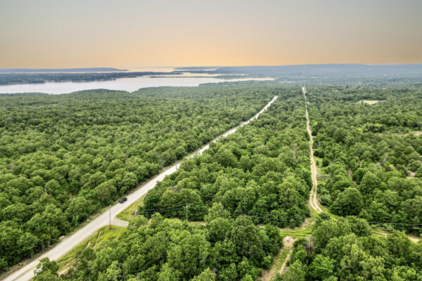
This amazing treed lot is located East of Huntingdon, TN and just 17 miles from town. Camden, TN is just 16 minutes’ drive to buy your groceries and daily needs, including a Walmart Supercenter, an airport and a Dollar Tree, A complete list of stores and restaurants is below.
There are also wonderful outdoor amenities nearby! Bring your family and friends in Natchez Trace State Park and Forest is just half an hour drive from the property and enjoy different activities like boating, fishing, hiking and camping. Outdoor activities like fishing, hiking or walking trails can be experienced in Johnsonville State Historic Park just 17 miles away from property. Message us today. We can offer Seller Financing! Please note that this property has a $299 doc fee that is non refundable.
Nearby Locations:
Benton County Airport – 5.5 miles
Thompson Machinery – 6.2 miles
Walmart Supercenter – 6.6 miles
Dollar Tree Store – 6.7 miles
Benton Sports Complex – 6.9 miles
Little City Café – 7.3 miles
Brewer’s Discount Grocery – 7.7 miles
Carroll Bank & Trust – 8.6 miles
Shell Gas Station – 8.6 miles
McDonald’s – 8.7 miles
Wendy’s – 8.7 miles
Camden General Hospital – 8.8 miles
Cash Saver – 9.0 miles
Dollar General – 9.0 miles
| Property Details | |
| Size (Acres) | 10 |
| Best Attribute | Near Recreational Areas and Stores |
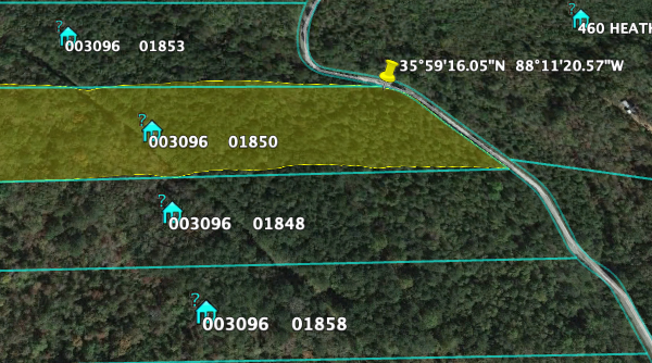
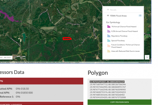
| APN or Other ID | 096-018.50 |
| Legal Description | A tract of land in the Second Civil District of Benton County, Tennessee, being Parcel 18.48, Tax Map 96, Tract 29 of Natchez Trace Farm Tracts, bounded on the North by Tract 30, on the East by Tract 20A… |
| Approximate GPS Coordinates | 35.987056992007,-88.1880028096539 |
| Property Type | Rural Land |
| Zoning | Estate – Residential |
| The county does not have a codes ordinance or residential zoning so there is a lot of flexibility. However, the mayor is proposing a County Codes system to cover the basics (safety, construction, nuisance issues). They are reliant upon the state law currently so when they get nuisance, littering, etc. issues they have to charge the state code in citations. This cost a great deal more to the citizen as well as does not serve the county well in the red tape it causes. | |
| Power | Nearest power post is about .3 miles away from the property. |
| Terrain | Property is gently sloped. |
| Water | Well Can Be Drilled |
| Sewer | There is no sewer systems outside of the City of Camden area. You will need to get a perk test before installing septic. |
| Roads | Access from Kee Lane aka Sycamore Drive |
| Flood Zone | Not in a flood zone |
| Title Info | Clear Title – Purchased through a title company. |
Taxes: $100
Tax Status: Paid
Leins: None
HOA: None
Complete Legal Desc: Beginning at an iron pin set (capped BMA RLS 898) as all that follow at the Southeast corner of the herein described tract (Tract 30) on the East side of Sycamore Drive & on the West bank of drainage ditch, the Northeast corner of Tract 29, the Southwest corner of Tract 31 and Northwest corner of Tract 20A; thence with road for two calls: North 45 degrees 01 minutes 49 seconds West, 179.51 feet to an iron pin set and North 39 degrees 37 minutes 51 seconds West, 193.34 feet to an iron pin set at the Northeast corner of this tract and the Southeast corner of Tract 48; thence with Tract 48 crossing road, South 85 degrees 12 minutes 50 seconds West, 974.44 feet to an iron pin set on the East bank of Cotton Creek; thence crossing said creek and continuing same bearing an additional 426.52 feet to an iron pin set in the East boundary of Tract 33 at the Northwest corner of this tract; thence with Tract 33, South 17 degrees 55 minutes 31 seconds East, 303.65 feet to an iron pin set at the Southwest corner of this tract and the Northwest corner of Tract 29; thence with North line of Tract 29 (portion of Parcel 18; Map 96), North 85 degrees 12 minutes 50 seconds East, 683.52 feet to an iron pin set on the East bank of Cotton Creek and continuing same bearing an additional 874.86 feet to the beginning containing 10.000 acres as surveyed August 31, 1991, by Robert G. Barrett, TRLS 898.
The above described is encumbered by a 50 foot wide access easement for the benefit of the original tract and other Grantees thereof for the purpose of construction and maintenance of roads and utilities over both the East and West ends as described.
NE: 35.987066, -88.188010
SW: 35.986102, -88.192930
SE: 35.986298, -88.187588
Center 35.986540, -88.190359
Property Location
Property Location
Discounted Cash Pricing
Cash Price: $11,999
Doc & Reservation Fee: $299
Total: $12,298
Deposit Amount: $3,999
Terms Pricing
Terms Price: $16,999
Down Payment: $3,999
Interest Rate: 10%%
Monthly Payment: $476
Montly Loan Fee : $20
Total Term months : 36
Property Location
Property Details
Size (Acres)
5.54
Best Attribute
Wide Open Space
APN or Other ID
70235760
Legal Description
LOT 1704, BLOCK 113, SANGRE DE CRISTO RANCHES, UNIT J, COSTILLA COUNTY, COLORADO
Approximate GPS Coordinates
37.364998, -105.342107
Property Size
Rural Land
Zoning
Estate – Residential
General Elevation (in feet)
8554
Power
Would be alternative power source.
HOA/POA
SDCR – Membership is optional for $25/year
Water
Well Can Be Drilled
Sewer
Septic can be installed
Roads
Dirt Road
Terrain
Property on rolling hills
Title Info
Clear Title
Annual Property Taxes (Approx)
$115.64
ALL THE INFORMATION WE HAVE ON THIS PROPERTY IS DISCLOSED WITHIN THE CONTENT OF THIS LISTING PAGE. IN MOST CASES WE HAVE NOT SEEN THE PROPERTY. ANY AND ALL OTHER QUESTIONS REGARDING THIS PROPERTY SHOULD BE DIRECTED TOWARD THE CITY OR COUNTY OF WHICH THE PROPERTY IS LOCATED IN. YOUR DUE DILIGENCE SHOULD BE PERFORMED PRIOR TO BUYING, TO ENSURE THE PROPERTY MEETS YOUR NEEDS AND CRITERIA.
Thank you for considering Liberty Land Sales
Related Properties
Contact Seller
This amazing treed lot is located East of Huntingdon, TN and just 17 miles from town. Camden, TN is just 16 minutes’ drive to buy your groceries and daily needs, including a Walmart Supercenter, an airport and a Dollar Tree, A complete list of stores and restaurants is below.
There are also wonderful outdoor amenities nearby! Bring your family and friends in Natchez Trace State Park and Forest is just half an hour drive from the property and enjoy different activities like boating, fishing, hiking and camping. Outdoor activities like fishing, hiking or walking trails can be experienced in Johnsonville State Historic Park just 17 miles away from property. Message us today. We can offer Seller Financing! Please note that this property has a $299 doc fee that is non refundable.
Nearby Locations:
Benton County Airport – 5.5 miles
Thompson Machinery – 6.2 miles
Walmart Supercenter – 6.6 miles
Dollar Tree Store – 6.7 miles
Benton Sports Complex – 6.9 miles
Little City Café – 7.3 miles
Brewer’s Discount Grocery – 7.7 miles
Carroll Bank & Trust – 8.6 miles
Shell Gas Station – 8.6 miles
McDonald’s – 8.7 miles
Wendy’s – 8.7 miles
Camden General Hospital – 8.8 miles
Cash Saver – 9.0 miles
Dollar General – 9.0 miles
| Property Details | |
| Size (Acres) | 10 |
| Best Attribute | Near Recreational Areas and Stores |
| APN or Other ID | 096-018.50 |
| Legal Description | A tract of land in the Second Civil District of Benton County, Tennessee, being Parcel 18.48, Tax Map 96, Tract 29 of Natchez Trace Farm Tracts, bounded on the North by Tract 30, on the East by Tract 20A… |
| Approximate GPS Coordinates | 35.987056992007,-88.1880028096539 |
| Property Type | Rural Land |
| Zoning | Estate – Residential |
| The county does not have a codes ordinance or residential zoning so there is a lot of flexibility. However, the mayor is proposing a County Codes system to cover the basics (safety, construction, nuisance issues). They are reliant upon the state law currently so when they get nuisance, littering, etc. issues they have to charge the state code in citations. This cost a great deal more to the citizen as well as does not serve the county well in the red tape it causes. | |
| Power | Nearest power post is about .3 miles away from the property. |
| Terrain | Property is gently sloped. |
| Water | Well Can Be Drilled |
| Sewer | There is no sewer systems outside of the City of Camden area. You will need to get a perk test before installing septic. |
| Roads | Access from Kee Lane aka Sycamore Drive |
| Flood Zone | Not in a flood zone |
| Title Info | Clear Title – Purchased through a title company. |
Taxes: $100
Tax Status: Paid
Leins: None
HOA: None
Complete Legal Desc: Beginning at an iron pin set (capped BMA RLS 898) as all that follow at the Southeast corner of the herein described tract (Tract 30) on the East side of Sycamore Drive & on the West bank of drainage ditch, the Northeast corner of Tract 29, the Southwest corner of Tract 31 and Northwest corner of Tract 20A; thence with road for two calls: North 45 degrees 01 minutes 49 seconds West, 179.51 feet to an iron pin set and North 39 degrees 37 minutes 51 seconds West, 193.34 feet to an iron pin set at the Northeast corner of this tract and the Southeast corner of Tract 48; thence with Tract 48 crossing road, South 85 degrees 12 minutes 50 seconds West, 974.44 feet to an iron pin set on the East bank of Cotton Creek; thence crossing said creek and continuing same bearing an additional 426.52 feet to an iron pin set in the East boundary of Tract 33 at the Northwest corner of this tract; thence with Tract 33, South 17 degrees 55 minutes 31 seconds East, 303.65 feet to an iron pin set at the Southwest corner of this tract and the Northwest corner of Tract 29; thence with North line of Tract 29 (portion of Parcel 18; Map 96), North 85 degrees 12 minutes 50 seconds East, 683.52 feet to an iron pin set on the East bank of Cotton Creek and continuing same bearing an additional 874.86 feet to the beginning containing 10.000 acres as surveyed August 31, 1991, by Robert G. Barrett, TRLS 898.
The above described is encumbered by a 50 foot wide access easement for the benefit of the original tract and other Grantees thereof for the purpose of construction and maintenance of roads and utilities over both the East and West ends as described.
NE: 35.987066, -88.188010
SW: 35.986102, -88.192930
SE: 35.986298, -88.187588
Center 35.986540, -88.190359
Property Location
Property Location
Discounted Cash Pricing
Cash Price: $11,999
Doc & Reservation Fee: $299
Total: $12,298
Deposit Amount: $3,999
Terms Pricing
Terms Price: $16,999
Down Payment: $3,999
Interest Rate: 10%%
Monthly Payment: $476
Montly Loan Fee : $20
Total Term months : 36

